
Live Broadcasting by Ustream
Sunday, May 2, 2010
Sunday Severe Weather Live Blog
Hello everyone, parts of Southeastern KY are currently under a tornado watch as well as a flash flood watch. Going ahead and posting up the live tools and I'll send out a tweet and FB status in case something moves into Laurel or the surrounding counties.
Live Broadcasting by Ustream
Live Broadcasting by Ustream


Sunday, April 25, 2010
Severe Wx Moving Out
Had some incredible severe weather over south eastern KY. The worst of it is moving out and now we're left with scattered showers and gusty winds until the cold front passes. I hope you enjoyed the severe weather coverage today. I'm worn out after it so to bed with me. Take care until next time!
Saturday, April 24, 2010
Live Severe Weather Blog 2 PM
15 
Latest local radar from Accuweather:
6:15 Update: Blog going live at 7:30 to track severe weather as it moves into eastern KY. Radar starting to act up a bit again but hopefully it will be worked out as we move into the evening.
4:15 PM Update: I'm hoping the rain we're seeing will help lessen the severe threat for later. However have to keep an eye out now for flash flooding.
2:00 PM Update: Live blog going to be postponed till we actually have severe weather in the area. Still having some issues with my GR Level 3 Radar updating. I will be posting here, on twitter @wxmanshane, and at Chris Bailey's weather blog (Link on the left hand side.)
1:35: Looks like a violent tornado rolled through the town of Yazoo, MS. Trained spotters on the ground reporting EF-4 damage. 1st line of showers moving into south eastern KY right now. These could have some gusty winds and lightning with them.
1:00 Update: Radar streams of level 3 data (What I use for my Radar stream) is overloaded. The last image to come in is almost 50 minutes old now. Also The Weather Channel reports of 30 homes being destroyed in Eagle Bend, Mississippi. Major tornado likely heading towards Yahoo City, MS.
12:50 Update: High Risk zone from SPC has been expanded to include portions of south central and western KY. Tornado Watch for that area coming soon.
Hey everyone, looks like severe weather will be heading our way later today. I'm going ahead and getting everything set up for a Live Severe Weather Blog to start at 2 PM. If the severe weather is not in our area by that point it will be pushed back but I wanted to go ahead and get everything set up and ready.
Live Broadcasting by Ustream
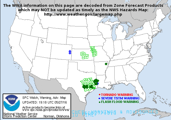
You can see live updating radar in the top box. I'm going to leave the latest from SPC down below:


Latest local radar from Accuweather:
6:15 Update: Blog going live at 7:30 to track severe weather as it moves into eastern KY. Radar starting to act up a bit again but hopefully it will be worked out as we move into the evening.
4:15 PM Update: I'm hoping the rain we're seeing will help lessen the severe threat for later. However have to keep an eye out now for flash flooding.
2:00 PM Update: Live blog going to be postponed till we actually have severe weather in the area. Still having some issues with my GR Level 3 Radar updating. I will be posting here, on twitter @wxmanshane, and at Chris Bailey's weather blog (Link on the left hand side.)
1:35: Looks like a violent tornado rolled through the town of Yazoo, MS. Trained spotters on the ground reporting EF-4 damage. 1st line of showers moving into south eastern KY right now. These could have some gusty winds and lightning with them.
1:00 Update: Radar streams of level 3 data (What I use for my Radar stream) is overloaded. The last image to come in is almost 50 minutes old now. Also The Weather Channel reports of 30 homes being destroyed in Eagle Bend, Mississippi. Major tornado likely heading towards Yahoo City, MS.
12:50 Update: High Risk zone from SPC has been expanded to include portions of south central and western KY. Tornado Watch for that area coming soon.
Hey everyone, looks like severe weather will be heading our way later today. I'm going ahead and getting everything set up for a Live Severe Weather Blog to start at 2 PM. If the severe weather is not in our area by that point it will be pushed back but I wanted to go ahead and get everything set up and ready.
Live Broadcasting by Ustream
You can see live updating radar in the top box. I'm going to leave the latest from SPC down below:

Friday, April 23, 2010
Severe Weather Possible Saturday
Hey everyone! I'm back with my thoughts on the potential for severe weather this weekend.
Thoughts outside of the video and summary:
*I think south eastern KY will see a few severe thunderstorms tomorrow. The majority of torandic activity stays west of us tomorrow, but not going to rule out a few storms going tornadic tomorrow.
*The main threats will be damaging winds, large hail, intense lightning and heavy rain.
*Some minor urban and stream flooding will be possible as we could see some heavy rains add up by Sunday morning. Here's HPC's thoughts on potential rainfall through Monday morning. However we need to rain, London is 4.66"s behind where it should be this time of year as of this morning.
 My thoughts on the timeline of events:
*A few stray showers and thunderstorms are possible over night tonight and early Saturday morning.
*By mid morning we catch a break in the action and will likely see some sunshine into early afternoon.
*By early afternoon *Say after 2 PM* we could see a few stray storms fire, these will have the best chance to produce large hail and tornadoes.
*Depending on how many of these stray showers pop will determine a bit of the impact of the main line of storms which moves through in the evening hours *Say after 6:30-7:00 PM*
*The line of storms moving through will drop heavy rain, have strong winds, lots of lightning and could spin up an isolated short lived twister.
I will take the blog live tomorrow afternoon here via Ustream with live up to the minute radar with analysis from me on any severe storms that enter Laurel or the surrounding counties. I will also have a chat going where you can ask questions and I'll answer. Until then keep an eye on the skies and turn those weather radios on. Take care!
Friday, March 12, 2010
Severe Weather Moving Out

Severe Weather is moving out of the blog's coverage area. I want to thank everyone that stopped by the live blog as we tested it out for the first day today. It is something I will do as often as possible when severe weather is moving through the area.

However we've seen some heavy rain over the last few hours and some local steams and creeks could come out of their banks. Keep an eye on water levels in you live in a flood prone area.
We could see more rain tonight as low pressure continues to cross the area. Here's Radar to track any more rain we see tonight:

Thanks once again for stopping by the old weather blog. I'll have updates as needed. Look for regular updates to begin again next Wednesday.
Sever Thunderstorms Possible Today
Hello everyone! After a week of gorgeous weather things are about to get pretty active across south eastern KY. A severe Thunderstorm Watch is now in effect for Laurel and all surrounding counties until 7 PM:

Here's a look at the latest local radar imagery where you can track the storms approach:

Satellite Imagery is showing a lot of cloud cover over the area... hopefully this will help limit instability and prevent the storms from becoming too strong:

If things start breaking loose this afternoon I MIGHT be trying out something I've wanted to do for a while with a live streaming Severe Weather Blog. We'll see if it is warranted and if I can actually pull it off. Until then stay weather aware and I will have more updates through the afternoon.
BTW: New Twitter Account: www.twitter.com/LondonKYweather

Here's a look at the latest local radar imagery where you can track the storms approach:
Satellite Imagery is showing a lot of cloud cover over the area... hopefully this will help limit instability and prevent the storms from becoming too strong:

If things start breaking loose this afternoon I MIGHT be trying out something I've wanted to do for a while with a live streaming Severe Weather Blog. We'll see if it is warranted and if I can actually pull it off. Until then stay weather aware and I will have more updates through the afternoon.
BTW: New Twitter Account: www.twitter.com/LondonKYweather
Severe Thunderstorm Watch
A severe Thunderstorm Watch is now in effect for Laurel and all surround counties in South Eastern KY until 7PM. I will have a break down of what's to come with in the hour.
Friday, March 5, 2010
Wonderful Weekend Weather
It's going to be an awesome weekend in southeastern KY this weekend, here's the latest video weather blog:
You can track temperatures this weekend on the left hand side of the page via KY Mesonet.
You can track temperatures this weekend on the left hand side of the page via KY Mesonet.
Tuesday, March 2, 2010

Monday, March 1, 2010
Southern Storm, Southern Snows?
Hey guys, testing some new video software today :
Highlights:
-Light Rain/Snow possible tomorrow through Thursday. Rain at day, snow at night.
-Much Warmer Weather heading our way for this weekend.
-Winter is not quite over yet...
Highlights:
-Light Rain/Snow possible tomorrow through Thursday. Rain at day, snow at night.
-Much Warmer Weather heading our way for this weekend.
-Winter is not quite over yet...
Friday, February 26, 2010
Finally Friday
Hello everyone! After an extended hiatus the blog is back with another post to give you some heads up about what's going on in the world of south eastern KY weather. We have some snow heading our way and you can track it right here on radar.
No watches or warnings for us in London and Laurel county and the surrounding areas. Not going to see enough snow to warrant and advisory but we could pick up an inch or two.
Here's the latest temperatures:

Winds:

Wind Chills:
 Here's what the NAM is saying about how much snow we could see by tomorrow evening:
 So maybe an inch or two is possible.
Here's a quick 5-day forecast for London, KY for you!:
Saturday: Mostly cloudy with snow showers. Low of 24, High of 34.
Sunday: Mostly cloudy with a few spotty flurries in the morning... becoming partly cloudy later. Low of 26, High of 38.
Monday: A mix of sun and clouds, Low of 22, High of 42.
Tuesday: Mostly cloudy with a slight chance of rain/snow. Low of 29, High of 36.
Wednesday: Chance of snow, otherwise mostly cloudy. Low of 24, High of 35.
Things to come:
-Keeping an eye on the middle of next to see how the next major storm system is going to evolve... right now we could get a glancing blow from this storm which could create March snow showers.
- No end to the cold and wet pattern at least through mid march, long range models and indicies continue to indicate ridging over the western US with a general trough pattern in the eastern US, which means cold and active weather for us.
-On a personal note, I'm working on a few things for the blog including:
*New style of video blog: Very similar to the style Accuweather does.
*Possibly expanding the coverage area of the blog.
*Inclusion of up to date weather graphics to make this a one stop weather shop.
*New Twitter account exclusive for this blog.
*New web adress.
So that's what's going on with me and the blog. Until next time, Take Care!
No watches or warnings for us in London and Laurel county and the surrounding areas. Not going to see enough snow to warrant and advisory but we could pick up an inch or two.
Here's the latest temperatures:

Winds:

Wind Chills:
 Here's what the NAM is saying about how much snow we could see by tomorrow evening:
 So maybe an inch or two is possible.
 Here's a quick 5-day forecast for London, KY for you!:
Saturday: Mostly cloudy with snow showers. Low of 24, High of 34.
Sunday: Mostly cloudy with a few spotty flurries in the morning... becoming partly cloudy later. Low of 26, High of 38.
Monday: A mix of sun and clouds, Low of 22, High of 42.
Tuesday: Mostly cloudy with a slight chance of rain/snow. Low of 29, High of 36.
Wednesday: Chance of snow, otherwise mostly cloudy. Low of 24, High of 35.
Things to come:
-Keeping an eye on the middle of next to see how the next major storm system is going to evolve... right now we could get a glancing blow from this storm which could create March snow showers.
- No end to the cold and wet pattern at least through mid march, long range models and indicies continue to indicate ridging over the western US with a general trough pattern in the eastern US, which means cold and active weather for us.
-On a personal note, I'm working on a few things for the blog including:
*New style of video blog: Very similar to the style Accuweather does.
*Possibly expanding the coverage area of the blog.
*Inclusion of up to date weather graphics to make this a one stop weather shop.
*New Twitter account exclusive for this blog.
*New web adress.
So that's what's going on with me and the blog. Until next time, Take Care!
Sunday, February 14, 2010
Quick Sunday Update
9 PM Update:
Everything looks to be on track, snow should start in our area of SE KY starting tomorrow morning around 3 AM for the heaviest of snows. More on this storm tomorrow, post what the weather is doing in your back yard in the comments section!
PREVIOUS UPDATE:
Hey everyone, a quick update on our winter storm which should start tonight. Still feeling pretty confident in my call map with just a few tweaks.

This map is a compromise between the GFS and NAM. I think the GFS has the better handle on the overall set up, but I believe the NAM is handling the potential for upslope snow better than the GFS.
Remember things should start in SE KY later on this evening, here's radar and temps:

Here's things to watch for today:
-Temps might get above freezing but I believe this should be mainly a snow even with a little rain mixed in.
-Keep an eye out tomorrow morning as the surface low crosses the state for it to tap the Gulf of Mexico for moisture and rapidly intensify. This will likely cause some heavy snow bands to set up and where they set up determines who gets the most snow.
-You will likely wake up with around 1-3"s on the ground tomorrow morning, remember this is a long duration event.
-Lake enhanced upslope starts tomorrow night and could last all the way into Thursday.
-Watching the potential for another winter storm next weekend.
Okay it's time for the Daytona 500, I'll have another quick update afterwards.
Everything looks to be on track, snow should start in our area of SE KY starting tomorrow morning around 3 AM for the heaviest of snows. More on this storm tomorrow, post what the weather is doing in your back yard in the comments section!
PREVIOUS UPDATE:
Hey everyone, a quick update on our winter storm which should start tonight. Still feeling pretty confident in my call map with just a few tweaks.

This map is a compromise between the GFS and NAM. I think the GFS has the better handle on the overall set up, but I believe the NAM is handling the potential for upslope snow better than the GFS.
Remember things should start in SE KY later on this evening, here's radar and temps:

Here's things to watch for today:
-Temps might get above freezing but I believe this should be mainly a snow even with a little rain mixed in.
-Keep an eye out tomorrow morning as the surface low crosses the state for it to tap the Gulf of Mexico for moisture and rapidly intensify. This will likely cause some heavy snow bands to set up and where they set up determines who gets the most snow.
-You will likely wake up with around 1-3"s on the ground tomorrow morning, remember this is a long duration event.
-Lake enhanced upslope starts tomorrow night and could last all the way into Thursday.
-Watching the potential for another winter storm next weekend.
Okay it's time for the Daytona 500, I'll have another quick update afterwards.
Saturday, February 13, 2010
Another Winter Storm...
Snow continues across parts of eastern KY this hour, but it's just an appetizer for whats to come.

The hits just keep on coming for southern KY this year, today a video blog updating the winter storm threat for tomorrow:
And totals:

I'll have more tomorrow.

The hits just keep on coming for southern KY this year, today a video blog updating the winter storm threat for tomorrow:
And totals:

I'll have more tomorrow.
Thursday, February 11, 2010
I Like This Winter... It's Exciting
To quote a line from the most recent adaption of Star Trek, this winter has been nothing short of historic across the eastern half of the US. We've seen some decent snowfall's this winter, enough to definitely run the school calendar back into June, and it looks like the hits are going to keep on coming. Let's talk about what's heading our way for Sunday into Monday. Today's model of choice for showing the situation is the GFS:
Sunday Afternoon:

Monday Early Morning:

Monday Late Morning:

Monday Afternoon:

So here's what's looking to be heading our way. A low pressure system will come out of Canada over the weekend and head towards the Ohio Valley this weekend. As it approaches it begins to intensify and tap into Gulf of Mexico moisture as it moves in KY. We already have an Arctic air mass and snow pack in place so temperatures will be cold enough for an all snow event. This storm is likely be under played at the surface right now as upper level dynamics look awesome to say the least. With upper level dynamics look so well and temperatures being very cold, and gulf moisture getting pulled into the equation, you are looking at a recipe for a possible solid snowstorm for most of KY. Here's what the latest GFS accumulation map looks like through Tuesday morning at 7 AM:

However, I think this map might be under doing totals and might be a bit to far north with where it wants to set up the heaviest band of precipitation. Let's look at what the storm is looking like it would drop if it we're all liquid.

That map shows between a quarter inch and half inch of liquid from Sunday to Tuesday morning. Now following the old ten to one rule, that'd be a good 2-5" snow for most of KY. However... with the air being as cold as it going to with this storm... snowfall ratios will likely start at 10:1 but end possibly as high as 25:1. If that happens you could tack a good extra 2-4"s on to that number if not more. This is a situation that I will closely be monitoring over the next couple of days. Until then take care.
Sunday Afternoon:

Monday Early Morning:

Monday Late Morning:

Monday Afternoon:

So here's what's looking to be heading our way. A low pressure system will come out of Canada over the weekend and head towards the Ohio Valley this weekend. As it approaches it begins to intensify and tap into Gulf of Mexico moisture as it moves in KY. We already have an Arctic air mass and snow pack in place so temperatures will be cold enough for an all snow event. This storm is likely be under played at the surface right now as upper level dynamics look awesome to say the least. With upper level dynamics look so well and temperatures being very cold, and gulf moisture getting pulled into the equation, you are looking at a recipe for a possible solid snowstorm for most of KY. Here's what the latest GFS accumulation map looks like through Tuesday morning at 7 AM:

However, I think this map might be under doing totals and might be a bit to far north with where it wants to set up the heaviest band of precipitation. Let's look at what the storm is looking like it would drop if it we're all liquid.

That map shows between a quarter inch and half inch of liquid from Sunday to Tuesday morning. Now following the old ten to one rule, that'd be a good 2-5" snow for most of KY. However... with the air being as cold as it going to with this storm... snowfall ratios will likely start at 10:1 but end possibly as high as 25:1. If that happens you could tack a good extra 2-4"s on to that number if not more. This is a situation that I will closely be monitoring over the next couple of days. Until then take care.
Tuesday, February 9, 2010
Winter Storm Part Deux
WED 2 PM Update:
Snow continues to fall at an incredible rate across SE KY, even more than I thought was going to roll through. I've heard reports of up to 6"s in Whitley and Laurel counties. This is an impressive event to say the least and I got burned a bit by it. Oh well, live, learn, and do better next time. I'll have more later, but for now enjoy the snow!
Welcome back and hope you are having a wonderful Tuesday. This morning started off with a bit of wintry precipitation across southeastern KY, but quickly changed to a cold February rain. Well for you winter lovers, there is nothing worse than 35 degree rain. Well fret not, we're only half way through this winter storm, and now we wait for part two. We're going to do a traditional blog instead of a video blog today.

Here's a look at the national radar to watch as the snow should start filling in the Ohio valley from northwest to southeast as winds shift out of the northwest due to a upper level low pressure system passes through our neck of the woods. These two factors together should create a decent snowfall event for much of Kentucky starting tonight and lasting until Thursday morning.

Keep an eye on local temperatures as an Arctic Cold front is passing through the area as we speak. They should begin to rapidly drop in the next few hours. One thing we will have to watch for is refreezing of water on local roadways.
The NAM model shows snow starting tonight around Midnight for us and keeping it around through Thursday morning:
Wed Early Morning:

Wed Evening:

Thu Morning:
 The GFS is showing decent snowfall totals for us, while the NAM isn't which is a bit confusing considering the NAM is showing precip over the area and it will most definitely be cold enough for snow.
NAM:

GFS:

So here's my thoughts for Totals through Thurs evening:
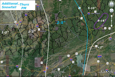
So most of SE KY gets an additional 1-3"s with the mountains of eastern KY getting 2-5". Tomorrow will be very windy, cold and blustery with blowing snow so be careful while traveling and make sure to stay warm. Wind Chills could go below zero tomorrow night so be on the look out for that. We'll have more on how things are playing out and a look at the extended range forecast tomorrow, so until then take care!
Snow continues to fall at an incredible rate across SE KY, even more than I thought was going to roll through. I've heard reports of up to 6"s in Whitley and Laurel counties. This is an impressive event to say the least and I got burned a bit by it. Oh well, live, learn, and do better next time. I'll have more later, but for now enjoy the snow!
Welcome back and hope you are having a wonderful Tuesday. This morning started off with a bit of wintry precipitation across southeastern KY, but quickly changed to a cold February rain. Well for you winter lovers, there is nothing worse than 35 degree rain. Well fret not, we're only half way through this winter storm, and now we wait for part two. We're going to do a traditional blog instead of a video blog today.

Here's a look at the national radar to watch as the snow should start filling in the Ohio valley from northwest to southeast as winds shift out of the northwest due to a upper level low pressure system passes through our neck of the woods. These two factors together should create a decent snowfall event for much of Kentucky starting tonight and lasting until Thursday morning.

Keep an eye on local temperatures as an Arctic Cold front is passing through the area as we speak. They should begin to rapidly drop in the next few hours. One thing we will have to watch for is refreezing of water on local roadways.
The NAM model shows snow starting tonight around Midnight for us and keeping it around through Thursday morning:
Wed Early Morning:

Wed Evening:

Thu Morning:
 The GFS is showing decent snowfall totals for us, while the NAM isn't which is a bit confusing considering the NAM is showing precip over the area and it will most definitely be cold enough for snow.
NAM:

GFS:

So here's my thoughts for Totals through Thurs evening:

So most of SE KY gets an additional 1-3"s with the mountains of eastern KY getting 2-5". Tomorrow will be very windy, cold and blustery with blowing snow so be careful while traveling and make sure to stay warm. Wind Chills could go below zero tomorrow night so be on the look out for that. We'll have more on how things are playing out and a look at the extended range forecast tomorrow, so until then take care!
Monday, February 8, 2010
Watching a Winter Storm
Hey folks, we're set for another winter storm across parts of SE KY. Here's a vlog to break it all down.
Here's my totals map:

Radar to track the wintry mess, and temperatures as they will play a big part in what we see tomorrow.

2:30 AM UPDATE:
Well folks my concerns about ice don't look like it's going to play out. Should mainly be a cold rain for folks east of Glasgow and south of Mount Vernon. We've got too much warm air at the surface right now and it looks like it won't be kicked up until our arctic front arrives. Snow is still possible tonight through Wednesday.
Here's my totals map:

Radar to track the wintry mess, and temperatures as they will play a big part in what we see tomorrow.

2:30 AM UPDATE:
Well folks my concerns about ice don't look like it's going to play out. Should mainly be a cold rain for folks east of Glasgow and south of Mount Vernon. We've got too much warm air at the surface right now and it looks like it won't be kicked up until our arctic front arrives. Snow is still possible tonight through Wednesday.
Thursday, February 4, 2010
Umbrella's Needed Tomorrow

Hey everyone, thanks for stopping by the old weather blog. Today another Vlog to talk about this weekend's system:
Here's a quick break down of the 5-day forecast:
Fri: Rain showers likely, could be heavy at times. Low: 33 High:38
Sat: Wintry mix just before and after midnight changing to all snow by dawn. Low: 27 High:33
Sun: Clouds decreasing throughout the day. Low 23 High: 30
Mon: Mostly sunny during the day with snow possible at night. Low: 21 High: 33
Tues: Wintry Mix possible, looking mainly snow at this time. Low: 28, High: 34.
Here's a look at Tuesday according to the japanese forecasting model, winter lovers enjoy the eye candy.

This is a storm to keep an eye on as it could yield some decent snowfall totals for southern KY. We'll have more on it over the weekend. Until next time, take care!
Wednesday, February 3, 2010
Wintry Rains?
My latest update on the storm system to affect southeastern KY this weekend. Bust out the umbrellas, it's looking soggy.
Monday, February 1, 2010
A Look Ahead Vlog
Welcome back to the old weather blog! Hope you had a wonderful day, my day has been a bit long so to keep from typing we're going Vlog style today:
Subscribe to:
Posts (Atom)

 Posts
Posts


