Tuesday, May 5, 2009

Flood Threat Continues

Happy Cinco de Mayo everyone! I wish the weather was a little dryer to celebrate, but alas we are stuck with more rain. Chances of rain are in your 5-day forecast.

Tuesday: Scattered showers and thunderstorms, otherwise mostly cloudy. High of 75.

Wednesday: Scattered showers and thunderstorms, otherwise mostly cloudy. High of 68, Low of 62.

Thursday: More of the same, scattered showers and thunderstorms, otherwise mostly cloudy. High of 77, Low of 55.

Friday: Once again more scattered showers and thunderstorms, otherwise mostly cloudy. High of 72, Low of 58.

Saturday: More scattered showers and thunderstorms, otherwise mostly cloudy. High of 63, Low of 56.


Forecast Discussion:

So the wet pattern continues. So what exactly is causing this extended period of unsettled weather? I'll try to answer that for ya. Basically the jet stream is a parked right on top of us.


And as it kind of waves back and forth on top of us for the next week, we'll see small low pressures systems over top of us, each one bring us a chance of showers and thunderstorms. And the possibility is there to see more heavy rain. Here's the 7-day rain out look from HPC:

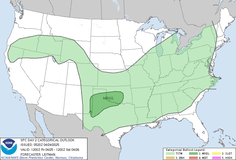
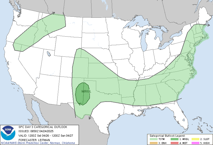
4 inches of rain over the next week is the last thing southern KY needs right now. There were already several reports of flooding over the weekend, and if we keep adding on more and more rain I suspect it will only get worse. We also have a slight chance at severe weather for Wednesday and Thursday.

Wed:


Thurs:

I'll keep an eye on it and will have more info as it becomes available. I'm working morning shift again tomorrow so I'm not sure when I'll update again just yet. We'll talk again soon.

Monday, May 4, 2009

Flooding LIkely Tonight

Hey Folks, no 5-day tonight, that'll come tomorrow... we've got flooding issues at hand... here's the latest from the NWS.

BULLETIN - EAS ACTIVATION REQUESTED
FLASH FLOOD WARNING
NATIONAL WEATHER SERVICE JACKSON KY
1148 PM EDT SUN MAY 3 2009

THE NATIONAL WEATHER SERVICE IN JACKSON KY HAS ISSUED A

* FLASH FLOOD WARNING FOR...
EAST CENTRAL LAUREL COUNTY IN SOUTH CENTRAL KENTUCKY...
EASTERN WHITLEY COUNTY IN SOUTH CENTRAL KENTUCKY...
BELL COUNTY IN SOUTHEAST KENTUCKY...
CLAY COUNTY IN SOUTHEAST KENTUCKY...
WESTERN HARLAN COUNTY IN SOUTHEAST KENTUCKY...
KNOX COUNTY IN SOUTHEAST KENTUCKY...
SOUTHERN LESLIE COUNTY IN SOUTHEAST KENTUCKY...

* UNTIL 545 AM EDT

* AT 1144 PM EDT...NATIONAL WEATHER SERVICE DOPPLER RADAR INDICATED
A BAND OF VERY HEAVY RAINFALL MOVING INTO THE WARNED AREA PRODUCING
RAINFALL RATES OF UP TO THREE-QUARTERS OF AN INCH PER HOUR.

* LOCATIONS IN THE WARNING INCLUDE BUT ARE NOT LIMITED TO AREAS IN
THE VICINITY OF BARBOURVILLE...HARLAN...HYDEN...LOYALL...
MANCHESTER...PINEVILLE...MIDDLESBORO...SOUTH WALLINS AND WALLINS
CREEK.

FLASH FLOODING WILL LIKELY BE CAUSED AS VERY HEAVY RAIN FALLS ACROSS
THE AREA IN COMBINATION WITH RUNOFF FROM RECENT RAINS. BE ESPECIALLY
CAUTIOUS AT NIGHT WHEN IT IS HARDER TO RECOGNIZE THE DANGERS OF
FLOODING. IF FLASH FLOODING IS OBSERVED ACT QUICKLY. MOVE UP TO
HIGHER GROUND TO ESCAPE FLOOD WATERS. DO NOT STAY IN AREAS SUBJECT
TO FLOODING WHEN WATER BEGINS RISING. ALSO...WHEN ENCOUNTERING
FLOODED ROADS MAKE THE SMART CHOICE...TURN AROUND... DONT DROWN

So just how much rain have we seen? Here's a look at Doppler Estimates:

Those Darker reds indicate over 5 inches of rain in parts of McCreary County. Streams and rivers are likely to rise over night and through the day tomorrow so if you live in a flood prone area keep a sharp eye on the water level. That's all I've got for tonight, we'll talk more tomorrow.

Tuesday, April 28, 2009

Dust Off The Rain Gear

Thanks for stopping by the old blog. After a couple of days at home I'm feeling recharged, and ready to make a post before I hit the road back to West Virgina.

Your 5-day Forecast For London, KY:

Tuesday: Our sunshine gives way to clouds, rain, and maybe even a thunderstorm by early afternoon. High of 77, Low of 59.

Wednesday: Showers and Thunderstorms Continue, otherwise Mostly Cloudy. High of 74, Low of 58.

Thursday: Showers and Thunderstorms again, and again Mostly Cloudy when it's not raining. High of 75, Low of 61.

Friday: You guessed it, more showers and thunderstorms. High of 72, Low of 57.

Saturday: Rain Rain go away, come again another day... High of 68, Low of 46.

I'll post up a forecast discussion once I get back to WV to explain what's going on. In the mean time you can track where the rain is on the radar at the bottom of the page.