
Wednesday, September 9, 2009

Still a Chance of Showers

Welcome back to the blog. Today will feature a lower chance at showers than the last few days, but we still could see a few pop up later this afternoon. Here's a radar to track any showers if they do pop.


Highs today should climb up to the low 80s. We're keeping an isolated shots of showers in the forecast now through Saturday, and you can see that on today's update 5-day forecast.


A quick break down of the next week.

-Scattered showers are still possible tomorrow, with more isolated chances Friday and Saturday.

-I lowered highs for Friday-Sunday as it does look we will get caught in a northwestern flow, which can cause more clouds and bring in cooler air.

-I think Sunday will be partly sunny with a chance of showers moving in late.

- As the cold front moves in Monday temperatures will be noticeably cooler, and the chance for heavy rain will be there.


Follow me on Twitter @WxmanShane

Long Range Discussion:

The models continue to struggle with the long range with a big time low pressure trying to cut off over the central of the nation at the end of this weekend. They've now flip flopped positions with the GFS and Euro keeping us dry at the beginning of the next week and the Canadian being the lone wolf showing frontal passage. Here's a look at the models for Monday Morning.

GFS


Euro

Canadian
So my thoughts are now a bit torn. I had agreed with the Euro and GFS for the last two days, but the Canadian is the most consistent, and it has slowed down the speed of which it was trying to move everything through. I'm going to hold steady with the forecast for now but some adjustments will be coming tomorrow depending on how the 0z runs tonight and 12z runs play out tomorrow. The models are notrious for sturggling with cut off lows and this one is going to be no exception. In other long range news here's the latest month 8-14 day outlook from the CPC.
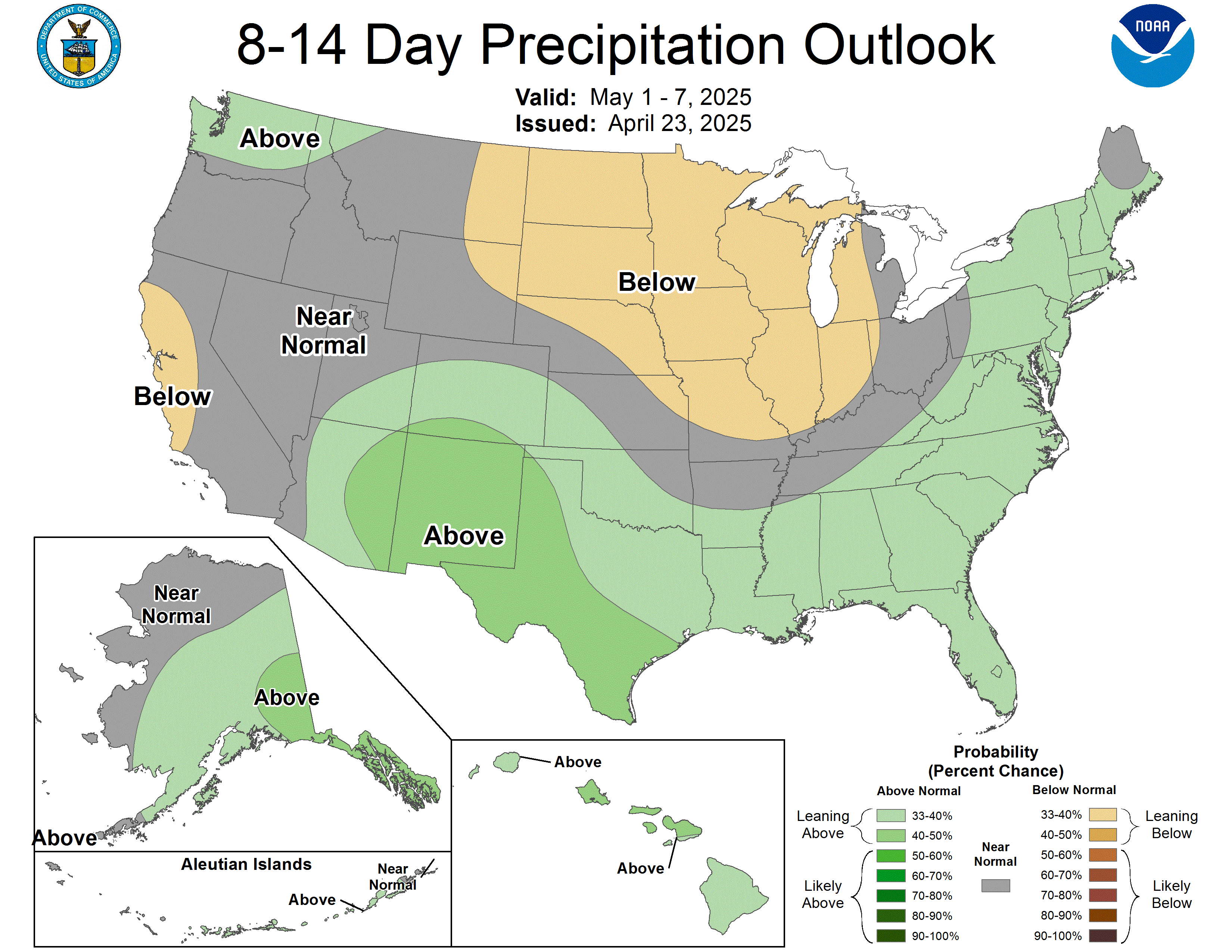
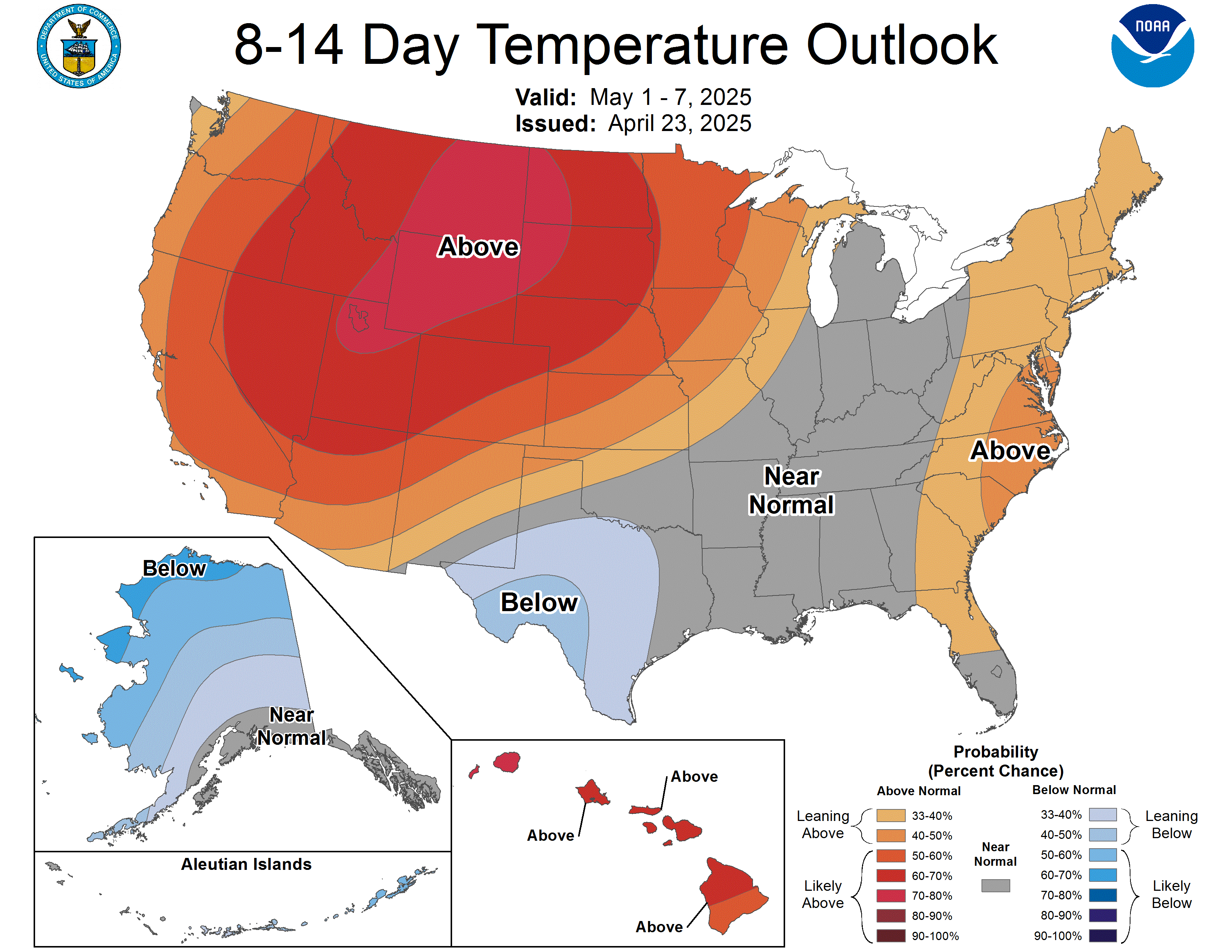
Both maps show us staying cooler and wetter than normal, over the time period. Chris Bailey has been playing up a cool down coming in the middle of the month and the CPC agrees. Just for fun look at the 850mb Temps from the 0z GFS ensemble run this morning.

It's showing a heck of a trough digging out over the eastern half of the US. Those greens over Canada show where the freezing line is at 850 mbs (about 5000 feet up in the atmoshpere.) Could we see temperatures that cold get to the surface by the end of the month. We'll just have to wait and see.

Tropics:

Just because we have a Category 3 Hurricane out in the Atlantic, I'd figure we could go take a look at it.


Here's Hurricane Fred. Current speeds 115 mph, making it a category 3 on the Saffir-Simpson Scale. Here's a look of Satellite and where the forecast models are taking him.


As you can see, looks like Fred's going to be a fish and just swim in the ocean.

Long two part post today, short update coming tomorrow since it's back to work. Take care!

Tuesday, September 8, 2009

Deja vu Weather

It's really going to fill like deja vu out there over the next couple of days as we keep scattered showers and the occasional thunderstorm in the forecast through the end of your shortened work week. Here's a look at local radar to see if you have rain heading towards you.


Our pesky upper level low continues to chill out over the Ohio Valley. As I mentioned yesterday until it leaves the area or falls to pieces we will keep at least a chance of scattered showers in the forecast.


Forecast Discussion:

So at least for the next couple of days, weather should be fairly straight forward across the southern part of the Bluegrass State. Our upper level low hangs out until around Friday bringing us chances of scattered showers off and on throughout each day, mainly in the afternoon hours. If we can keep the cloud cover and rain away until after around 3 or 4 PM each day, our highs should make it to right around 80... if they move in and stick around a little while I think mid to upper 70's for highs. Dense fog could develop if we clear out after having rain in the afternoon like yesterday.

Now comes the fun part of the forecast with the weekend and beyond. A powerful low pressure system looks to be moving into the nations heartland this weekend and then try to cut off and become semi-stationary. The question is when does the cold front associated with it move in to effect our weather. The GFS and Euro are in decent agreement, while the poor Canadian is out in the left field. Here's a look at where they have the low come Sunday morning.

GFS


Euro


Canadian

The GFS and Euro both have the low over Nebraska Sunday morning, while the Canadian is showing it up over Canada with the trough digging in to the Ohio Valley. I'm still continuing to lean more towards the GFS and Euro solution for now... which would like me we will hold of the bulk of the showers till after the weekend.

That's all I have for now, be sure to follow me on Twitter @WxManShane! Take care!

Monday, September 7, 2009

Welcome to the Unofficial End of Summer

Labor Day's been a bit soggy so far today. Here's a look at your local radar.


I think we should catch a break in the action later in the day so you might be able to squeeze in a little labor day cook out later this evening.

Here's a look at your 5-day Forecast:

Forecast Discussion:

Hey folks, long time no see. I figure as we head into the fall and winter months I'd get the old blog up and running again. As you can see in the 5-day forecast above, things are looking a bit soggy as we finish out the week and here's why.


We have a bit of an upper level disturbance over the area right now. It's providing just enough instability to spark off showers and a few thunderstorms as it sits over the area. Unfortunately there's nothing to shove this disturbance on out of the Ohio Valley, so we're stuck with it for the next few days. I don't think we see wall to wall rain, but we will see off and on showers and thunderstorms... much like the last two days.

I think by Saturday it should dissipate and leave us dry for the weekend though. Here's a look at the GFS for this weekend.

Saturday Afternoon


Sunday Afternoon


It should be noted the Canadian model is keeping us wet this weekend, but with the GFS and Euro both holding frontal passage back to Monday, I'm going to lean towards that line of thinking for now.

Before I go, HPC has a cool new product for you Google Earth users out there. They're now making their day 1-3 QPF (Quantitative Precipitation Forecast) available as a KML file, viewable in GE.

Here's a sample of what it looks like:


Here's a link to the KML products the NWS distrbutes. Click Here.