Wednesday: Isolated Showers possible, otherwise Mostly Cloudy. Low of 49, High of 76.
Actual: Low 53, High of 75.
Overall not a bad forecast, now your Five Day Forecast for London, KY:
Thursday: Showers and Thunderstorms are likely in the afternoon. Otherwise Mostly Cloudy. Low of 62. High of 75.
Friday: Scattered showers and thunderstorms possible, otherwise mostly cloudy. Low of 64, High of 74.
Saturday: Partly cloudy, with a chance of scattered thunderstorms. Low of 65, High of 80.
Sunday: A good chance of showers and thunderstorms. Temperatures look to be falling through the day with a morning high of 71, and a low that evening 48.
Monday: Partly Sunny. Chilly Morning low of 38, High of 67.
Forecast Discussion:
So things still seem on track from this mornings post. The NAM is really cutting back our chances of rain tomorrow as the front moves through:
Tomorrow Morning:

Tomorrow Afternoon:

I think it might be weakening those showers out a bit to much as the front moves into the area, but we will see. Things also look wet through the weekend, but finally High Pressure builds in at the beginning of next week.
GFS Monday Afternoon:
 Notice that mass of precip down in FL, that might be the first tropical system of the season trying to develop. I think that we should stay dry for the majority next week. High Pressure seems like it will build in for at least a couple of days, and it'll be a welcome sight to help flood recovery efforts.
Q&A:
Anonymous said...
Shane,
When will this pattern end? Do you see any indications in long range models that we might actually have more typical late spring weather? This rain and fronts stalling out is brutal. I'd love to see a strong High move our way and setup camp for a couple weeks. Thanks for the updates.
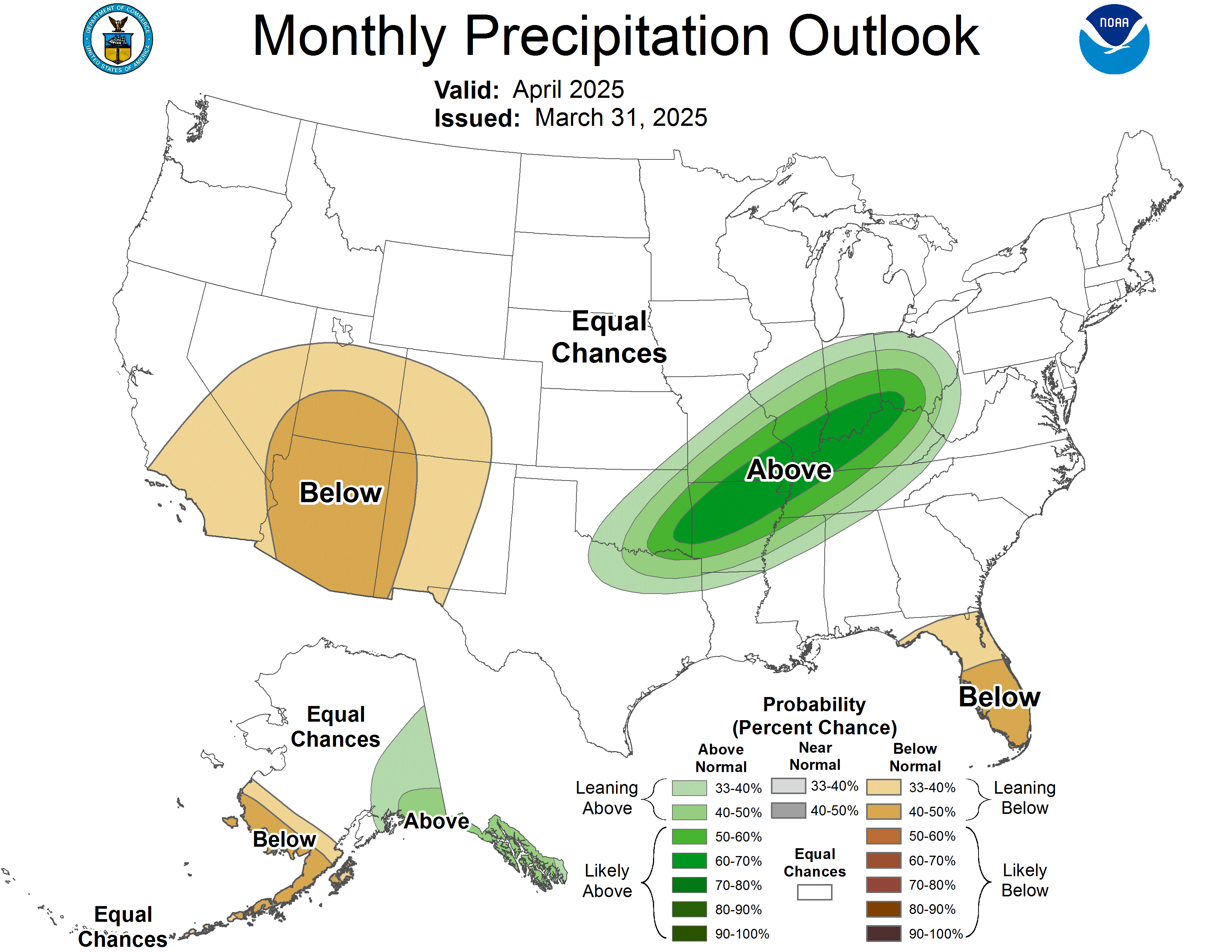
Well Anonymous, while I do see high pressure building in for the first part of next week, I'm not sold on the fact that'll we see see a big southeastern ridge build in the next few weeks. Most the things I look at for long range forecasting *Which is still my weakest area of forecasting, but I'm still trying to learn* point towards a continued active period in the weather. Next week like I said earlier shall be dry, but I don't think that ridge will hold. The CPC shows the next month to continue to be wetter than normal:
That's all for now, we'll talk again soon.


No comments:
Post a Comment