Saturday, January 31, 2009

It's Not Dead Yet Jim....

And just after I'm willing to put this winter storm in the ground, some of the models trend back to the west and the NGM pops up and yells, SURPRISE EAST SIDE MOUNTAIN RUNNER!

Aye yi yi yi yi.... Oi.... okay enough with the phonetic noises, on to your 5 day forecast:

Sunday: Sunny with a high near 56 and low of 32.

Monday: Start the day as Partly Cloudy, clouds increase and we could end the day with rain changing to snow. High of 46 Low of 30.

Tuesday: Snow is Likely, possibly heavy snow and temperatures will fall throughout the day. High of 25, Low of 18.

Wednesday: Wrap around snow from our Winter system is still possible, so going for a chance of scattered snow showers with a High of 23, and a low of 17.

Thursday:Mostly Sunny with a Low of 19 and a High of 34.

Forecast Review from Today: 15/40 Actual: 17/44 Okay not too bad today but not great, would've liked to have been closer to the high but felt good about the low.


Forecast Discussion: Tomorrow is looking great folks, Superbowl Sunday is going to be a treat so get out and enjoy it, maybe go on a Sunday Jog before the big game to enjoy the unseasonably warm temperatures we will see tomorrow.

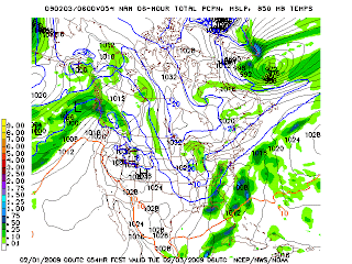
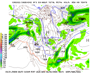
Now onto the zombie big daddy storm. This thing was dead to us, out to sea, good bye, so long, we were not going to see much from it... and then the 0z models hit. The GFS and NAM have both shifted back to the west, although the GFS is still taking this thing out to sea.

0z GFS:


NAM:


NGM:


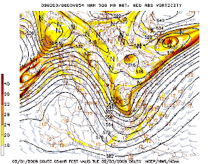
Okay, so there's the latest model runs, if you want snow hope for track like the NGM is showing, if you don't want much hope for the GFS. The upper air charts for the NAM and GFS are looking better for a storm that would bring more impact to KY, they hold the 500mb vorticity *Which is spin in the atmosphere* back over KY in the trough. The NGM does as well, but to a lesser Extent.

500 MB GFS


500 MB NAM


500 MB NGM


These charts would suggest the surface precip, might be to far to the east as they will want to be close to where all the energy *Spin* is.

Now just to round out the anaylsis, here's some Jet stream for ya.


GFS


NAM


NGM


The interesting thing of note here is all 3 models are showing phasing of the jets, or where they come together over east Georgia and Southern SC, or just off the coast of those states. Where the jets come together, you get intense cyclogenesis, which is weather man spaek for rapid formation and intensification of a low pressure system. If this were to happen over say Northern Gerogia, or western SC, then KY would be in the big time zone. At this point folks, I'm not exactly sure how much snow we're going to see. It's all going to depend on how the track continues to develop through the next 48 hours. I would say folks between I-65, and I-75, can expect less than 4 inches from this sytem. People west of there see little to nothing, People between I-75 and the WV/VA boarder see 3-7 inches *higher totals possible in the mountains.* People in WV see generally 6"+ from this thing. Okay, I'll make a quick map to illustrate.


This is assuming the low tracks somewhere between the path of the NGM, and the path of the NAM. If it takes the NGM's track, we see more snow, if it takes the NAM's path, we see less snow, if it takes the current GFS's path... what snow?

So there you have it folks, you want snow hope for a westward track, you want no snow hope for an easterly track, it's as simple as that. Hope you have a great time enjoying the Superbowl while I'm working :P, I'll be back with another update possibly tomorrow morning, or definitely after the big game.

The Winter Storm that Could've been

Well Folks, I've held out as long as I could. I can no longer justify that first call map Meteorolgoically, it just has too much model data going against it. Even if this storm starts shifting back to the west it would have to take one heck of a shift to get it back to where KY see's a decent snow. I think the best chances of any snow this week are East of I-75 and totals will be less than 3 inches across the board. Sorry folks, the models have just gone crazy and the shift they've taken just makes me sick. I know a lot of ya'll want a big snow, and it was looking good, but now it looks horrible.

Friday, January 30, 2009

Friday Evening Update

Hey folks, busy day at work, I'm pretty tuckered out so I'm going to be keeping this one brief, updated 5-Day, the latest on our winter storm, and a FIRST CALL TOTALS MAP!

So lets get to it, Your 5-day Forecast for London, KY

Saturday: A few morning flurries wrap up and leaves us with clear skies by the end of the day. A low of 15, and high of 40.

Sunday: Sunny with a high near 56 and low of 32.

Monday: Start the day as Partly Cloudy, clouds increase and we could end the day with rain changing to snow. High of 41Low of 27.

Tuesday: Snow is Likely, possibly heavy snow. High of 25, Low of 18.

Wednesday: Wrap around snow from our Winter system is still possible, so going for a chance of scattered snow showers with a High of 23, and a low of 17.

Forecast Review for Today: 32/27 Light Snow Actual: 34/26 Light Snow I called for nothing to an inch accumulation wise, which I guess techincally verified, but it was kind of a cop out, oh well LOL.

Winter Weather Discussion:

We have on our hands a fight between Americas top 2 models:


Wait a second... wrong kind of models.

The WEATHER models had locked onto a pretty nice set-up for eastern KY, and then boom, everything heads out to the east coast. 18z GFS from today:


And for 3 runs that is what the models have shown, an east coast storm. Except for the NAM! In it's 18z run it said hold up, It thinks this thing still runs inland a bit.

So this has been the talk of the Meteorological community today. It's lead to arguments, shouts of hallelujah, shouts of damnation, sighs, groans, and weather weenies jumping for joy, or wanting to throw themselves out of skyscraper windows.

So what's my take, well here we go FIRST CALL MAP!


Okay you're probably thinking, He's gone crazy! Maybe I have, but I'm still not convinced this storm is going to be an east coast runner, I think the models will come back to something closer to their earlier solutions. Watch for another dynamic model shift in 24 hours. This map will be adjusted many times over the coming days, and remember this is through Wednesday Evening, which is 5 days away, so take it worth a grain of salt right now.

And now it looks like HPC might be thinking heavy snow is again on the table for eastern KY, check out their probability maps for a 4"+ snow for day 3 *IE Monday*.


Oh Snap, maybe I'm not crazy after all! Maybe there is something to the east side of the apps track. Folks, we're still 72 hours out, this is going to be a storm we are fine tuning everything all the way through the storm, so just sit back, avoid the model madness, and stay abreast cause this could become something big.

Late Friday Update

No updated 5 day yet, that will come with a post sometime around 7 or 8 tonight. As far as our winter storm goes, my thoughts haven't changed any yet. The models are still showing the storm, they're just not agreeing on the their path. The 0z GFS and it's Ensemble shifted to a coastal type storm. I'm not going to stay up to look at the 0z CMC or Euro, I'll check them out first thing in the morning. I'm putting together a map on where I think the track of this low will go, and here it is.


As you can see, I'm still betting on a storm that runs up the east side of the apps, which would be good for snow for most of KY, especially east of I-75. Tomorrow I will adjust the track on this map, the timing of the low, and add snowfall totals first call! So something to look forward to tomorrow, until then, take care!

BTW, before I go, Possible dusting of snow in London tonight, keep an eye on the radar.

Thursday, January 29, 2009

Thursday Late Morning

Good Morning Bloggers, doing my upate a little early today because I'm working night shift tonight. Today an updated 5 day forecast, and then we talk about the monster of a storm looking to form early next week.

Your 5 Day Forecast for London KY:

Friday: A Clipper system crosses to our north, bringing us a chance of some light snow, otherwise we'll be mostly cloudy with a high of 32 and low of 27. Total Accumulation for London nothing to 1".

Saturday: A few morning snow showers wrap up and leaves us with partly cloudy skies by the end of the day. A low of 19, and high of 35.

Sunday: Sunny with a high near 50 and low of 32.

Monday: Start the day as Partly Cloudy, clouds increase and we could end the day with rain changing to snow. High of 41Low of 26.

Tuesday: Snow is Likely, possibly heavy snow. High of 25, Low of 18.

Forecast Review for Today: Forecast 25/33 Actual: 26/ 36 :Not a bad day of forecasting, 1 off the low, 3 off the high, I'll take it.

Forecast Discussion: No change in my opinions of the short term. Slight chance of snow for tomorrow due to a clipper moving through. An absolutely gorgeous weekend and should help the folks up north clean up and thaw out a bit before the mess that starts next week.

Winter Storm Possibilities: The Models are still holding on to our winter storm for next week. At this point it's game on, it just depends what are we in store for. There is still a lot of uncertainty on to the track of this storm, and as always track is everything for winter storms.

Right now the models aren't agreeing on a track. The GFS is going with a coastal runner:


The Japanese Model is also agreeing with the GFS on the coastal runner:


The Canadian is taking a more westerly track, taking it up the east side of the Appalachians:


The Euro is taking the storm right up the spine of the appalachains, which just doesn't happen often so I'm really discounting this run of the Euro:


So as you can see there is a couple of hundred mile spread in the track of the storm according to the 4 major global models. Which path do we go with, I say for now let's take a blend of the paths and see where that ends up.

My take on an average Track:


Okay so assuming this is the track of the low, what would the impact be, here's a map for that.

Major Impact: Major snowfall totals, generally more than 8-12"s of snow. Basically it would close roadways, and just make life a general pain for a couple of days

Significant Impact: This would be somewhere in the range of 4-10"s of snow. Once again roads and schools closed, and especially for central KY this would be bad as they're still cleaning up from the ice storm.

Moderate Impact: Less than 4"s of snow, schools closed maybe for a day or two, main highways should be passable.

That's just my take on the storm if it were to follow that track, not a forecast as to what will happen. My personal take on this track, is that it might be just a smidgen to far to the east, I'm thinking this storm will probably run up the east side of the mountains, which would push those lines farther west. We'll see what happens. Thanks for stopping by the blog, I'll have an update either tonight or tomorrow evening.

Wednesday, January 28, 2009

Wintry Wednesday Ends... Big Storm on the Horizion?

Good evening everyone and welcome back to the old weather blog. London was spared the worst of this winter storm, and to be honest I'd rather us seen all the rain we did than the ice central KY saw. Up next your 5 day Forecast, Storm Review, and a look into the future *Dusts off the old Magic 8 Ball.*

Your 5 Day Forecast for London KY:

Thursday: Mostly Sunny with a low of 23, and a high of 38.

Friday: A Clipper system crosses to our north, bringing us a chance of some light snow, otherwise we'll be mostly cloudy with a high of 32 and low of 27. Total Accumulation for London Dusting to 1".

Saturday: A few morning snow showers wrap up and leaves us with partly cloudy skies by the end of the day. A low of 19, and high of 34.

Sunday: Sunny with a high near 50 and low of 26.

Monday: Ah here comes the fun day, I'll talk about it more in the forecast discussion, but for now all you need to know is a chance of rain changing to snow, with a high of 34 and a low 27.

Forecast Review: Forecast: 46/27 Actual: 42/28 *Note temp is still falling so low could be a little lower*

Not to bad, 4 degree bust on the high is acceptable when there were reports in Knox county of 61! 20 Degree temperature spread in that many miles... CRAZY! None of the models had 60's in here, even the RUC was only putting 50's into southern KY, kudos to the folks out at KYmesonet for their hard work and getting all these observation sites up.

As far as snowfall totals, busted hard but I'm willing to take the hit. We barely got a dusting of snow in London, not an inch but oh well, snow didn't last as long as I thought and the ground was just too warm to hold the snow after a day of rain. BTW a note about the rain from London yesterday from the NWS in Jackson.

RECORD EVENT REPORT
NATIONAL WEATHER SERVICE JACKSON KY
1242 AM EST WED JAN 28 2009

...RECORD DAILY MAXIMUM RAINFALL SET AT LONDON...

THE DAILY RAINFALL TOTAL AT THE LONDON CORBIN AIRPORT WAS 1.54
INCHES ON TUESDAY JANUARY 27TH. THIS IS THE MOST PRECIPITATION EVER
RECORDED ON THIS DATE. THE PREVIOUS RECORD WAS 1.43 INCHES SET IN
1972.

So all and all, a hard forecast period, I'm glad we're done with it. I at least get a few days of breathing before the next challenge of this winter.

Forecast discussion:

Okay so the forecast for the next couple of days is going to be relatively easy compared to the last 72 hours of mess. A clipper system moves in tomorrow and could put down a dusting of snow, here's the GFS's take on it.


As you can see, it's not a very well organized system, so I'm not expecting much from it. Let's move it on to your weekend.


As you can see high presure is in control for Saturday and again on Sunday, on the back side of that high on Sunday temperatures could get above 50. Nice weekend to get out and enjoy because the mess rears it's ugly head on Monday into Tuesday.

WARNING: LONG TERM FORECAST DISCUSSION, Not an actual forecast, but discussion on the possibilities.

Okay wall of text and maps incoming, so considered yourself warned. This storm coming into the picture on Monday has been catching a lot of peoples attention for the last 72 hours. Since we're within the 5 day period it's time to adress it.

GFS for Friday Afternoon: Big time Low pressure off to our south, Temps below freezing at 850, lot's of QPF *Think of this as if everything fell as liquid precipitation in the 6 hour period for the model.* Now lets look at the precipitation total for the entire event according to the GFS.


Assuming that all fell as snow at a 10:1 frozen to liquid ratio, that would mean around 10 inches of snow for over half of KY! I am not forecasting that, that is just what this model is showing.

Time to look at the other long range models, Canadian, European, and Japanese:

Canadian

European


Japanese:


Okay, so all 4 long range models are showing it on the horizon for Monday night/Tuesday Morning. Also the GFS and Canadian Ensembles are showing similar solutions. So game on for massive snow right? Not so fast, Surface temps according to the 12z GFS and Canadian.

Monday Evening GFS:


Tuesday Morning:


Canadian:
Monday Evening:
Late Monday:
Tuesday Morning:

Okay so both of these models show a rain to snow transition. Now time to look at some upper air data, Looking at 3 levels, 300 MB's (30,000Ft) *Jetstream Level*, 500 MB's (18,000ft), and 850 MB's. (5,000ft)

300 MB Jetstream:

GFS:

Euro:


CMC:

Notice in all 3 model's, I've drawn a cross in the middle of the Jetstreak, the areas of most intense wind in the Jet Streak. In the quadrants I've put the astrics are the areas of the most intense lift, a key ingredient in getting precipitation, so the potential for heavy precipitation is there.


Okay 500 MB: Here we're looking at Vorticity, the amount of spin in the atmosphere. More Vorticity = Strong system in layman's terms.


GFS:


JMA:


CMC:


In all 3 Models here we see there is ample vorticity over eastern KY, lots of energy to work with.

Next 850, just going to show the GFS just to show my point with it.


On both these maps, I've circled areas of cold air advection, areas where cold air will move in and bring the temperatures down. Models have a hard time handling temeprature advection, so it's likely temperature will be colder than the models antcipate in these areas.

Okay so what does all this mean. The ingredients are coming together for a snowstorm this part of the country hasn't seen in about 16 years. Henry from Accuweather is calling this storm 75% of the Blizzard of 93. Folks invoking the Blizzard of 93 around here is liking invoking the name of Jesus Christ to a demon possessed person, it causes much gnashing of teeth, and shouts and outbursts of rage. For him to say that means he thinks it's on.

Chris Bailey is about to pull the trigger on a Winter Storm Threat 5 days out, something he very RARELY does. All the ingredients are there for a huge snowstorm, ample mositure, cold air, and a ton of lift.

What can go wrong between now and then... A lot. The models for the last decade have trended Northwestward with dang near every winter storm. What this means is that the storm would go farther west and north than the models would show in the 3-7 day range. An example of this was the early March storm last year which was showing significant snow up to the last 24 hours, and then shifted it's track west of the What else can go wrong, a storm like this requires a phasing of the Jet Streams, something the models don't pick up on very well. If this doesn't happen, our storm is a completely different storm than the one the models show right now.

So where do we go from here? The potential is there for a MASSIVE winter storm for most of the east coast next week. Do we see Blizzard of 93 or similar conditions, I just don't know at this point. From here we take it one day at a time, keep a vigilant eye on every model run, and if it's still showing what it showed today 24 hours before the event, be ready to ride out one heck of the storm.

My Forecast for Monday, Rain changing to snow at this point. This can change between now and Monday. Sorry for the wall of text weather explanation, but I wanted to break this down from a serious Meteorological prospective.
Good morning everyone, Quick morning updated before I head into work. I think thinks are looking on track for the forecast, with the exception of snow totals. I'm thinking highway 80 and south is going to be lucky to pick up 2 inches with as warm as it was down there over night. Here's the latest temperature and radar for you.


As you can that swath of snow isn't very wide, so if the forecast is going to have to verify it's going to have to put down a lot in a short period. This has been one tricky storm to forecast. i'll have an updated 5 day after work this evening, so until then have a great day and come back and see us later!