Sunday, January 31, 2010

Snow Recap and a Look Ahead

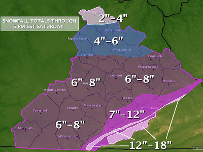
Welcome back to the blog for a snow recap and a look ahead at the next 5-days. I hope everyone had fun in the snow yesterday and didn't end up too cold this morning. Here's a Recap of the big snow event from the National Weather Service in Jackson:

HARLAN.......10 INCHES...16 INCHES ON BLACK MOUNTAIN
WAYNE........8 INCHES
JOHNSON......7 INCHES
FLOYD........7 INCHES
PIKE.........7 INCHES
WHITLEY......7 INCHES
MARTIN.......6 TO 8 INCHES
LETCHER......6 TO 8 INCHES
KNOTT........6 TO 8 INCHES
BELL.........6 TO 8 INCHES
LESLIE.......6 TO 7 INCHES
JACKSON......6 INCHES
LAUREL.......6 INCHES
LEE..........6 INCHES
BREATHITT....6 INCHES
ESTILL.......6 INCHES
MAGOFFIN.....6 INCHES
CLAY.........6 INCHES
ROCKCASTLE...6 INCHES
POWELL.......5 TO 7 INCHES
PULASKI......5 TO 6 INCHES
MCCREARY.....5 INCHES
KNOX.........5 INCHES
OWSLEY.......5 INCHES
PERRY........5 INCHES
WOLFE........5 INCHES
MORGAN.......4 INCHES
MENIFEE......4 INCHES
ELLIOTT......3 TO 6 INCHES
BATH.........2 INCHES
MONTGOMERY...2 INCHES
FLEMING......2 INCHES
ROWAN........1 INCH


So let's see how this compared to the final call forecast map:

And here's a look back at my first call map:

So overall I think I did a decent enough job with this storm. So let's look ahead to the next five days:

Monday: Mostly sunny, Low of 10, High of 38.

Tuesday: Chance of snow or wintry mix, otherwise M. Cloudy. Low of 27, High of 40.

Wednesday: Mostly Sunny with a Low of 25, High of 42.

Thursday: Mostly Sunny with a low of 27, High of 43

Friday: Chance of rain and or snow showers. Low of 30 High of 36 .

And now all I turns towards the end of next week and next weekend, for the possibility of another southern storm... does this one bring us snow, rain, or the stuff we don't like to talk about? Well it depends on which model you ask.

GFS:

Canadian:

Euro:
All of them want to start the event as rain on Friday, but there are some differences in how it ends. We will talk about that tomorrow, until then take care.

Saturday, January 30, 2010

Snowy Saturday

Good morning everyone and welcome to your snowy Saturday morning across southeastern KY! Here's a look at the current radar.


As you can see we still have a bit of snow to go in southeastern KY, probably another 4 hours or so. So my time line is playing out fairly well although the storm is moving a bit faster than I originially anticipated so it should wrap up soon than I expected in my posts on Thursday and Yesterday.

I would love to hear how much snow you have in your yard this morning, post your totals up in the comments section!

In the mean time here's your 5-day forecast for London KY:

Saturday: Snow showers wrap up and we should see some clearing overnight. High today of 26.

Sunday: Mostly Sunny but bitter cold in the morning. Low of 6, High of 28.

Monday: Mostly sunny, Low of 7, High of 33.

Tuesday: Chance of snow or wintry mix, otherwise M. Cloudy. Low of 27, High of 36.

Wednesday: Mostly Sunny with a Low of 25, High of 37.

More updates coming up later in the day!

Friday, January 29, 2010

And Now... We Wait

Good evening everyone just stopping by with a quick update on the snow situation going across the area.


As you can see snow is spreading over southern KY as we speak. I've already heard reports of dusting to an inch in most of south eastern KY. So far my time line from yesterday looks spot on track. Here it is again in case you missed it:

Friday Early Afternoon: Snow should start in Western KY including Bowling Green early afternoon, we will likely experience a period of Virga before the snow actually starts reaching the ground as the air will be very dry as our storm moves in.

Friday Night (After 6:00PM): Snow should be going across most of southern KY by this point, once again it will take a bit for it to get going as the atmosphere will have to moisten up a bit before the snow will hit the ground.

Friday Late (Around Midnight): Heavy snow across most of Southern KY, snow going at this point near the I-64 corridor. Snow getting going at moderate rates across the coal fields of WV. Areas seeing heavy snow at this time could see near white out conditions and along the TN, KY border you could see snowfall rates of 1-2"s per hour.

Saturday Morning (Around dawn): Moderate to heavy snow wrapping up in bowling green but continuing points east to include all of southern WV at this point. Many roads will likely be covered in many areas south of I-64 at this point.

Saturday Mid-day: Heaviest snow now located in far-eastern KY and most of southern WV. Snow really lightening up west of I-65. Light to moderate snowfall continues for area west of I-75 to I-65 through the late evening.

Saturday Evening: Flurries and light snow west of I-75, east of I-75 to the KY/WV/VA border, light to moderate snow, moderate snow hanging tough in southern WV.

Sunday Morning: Snow lingers in WV mountains, while most of southern KY wakes up to clear skies and temperatures in the single digits or possibly below zero.

So time line looks to be on track, however my totals from earlier might have been too conservative. Here's a look at the latest NAM and GFS snowfall totals:

NAM:

GFS:


The NAM is the preferred model this late in the game because of it's higher resolution. Also a great model to look at is the SREF (Short Range Ensemble Forecast), Let's see what it's latest run has to see for what would normally fall as liquid.

That's showing around .75"-1.00" liquid over much of our area. The snow will likely be falling at something higher than the normal 10-1 frozen to liquid ratio... probably something between 12-1 and 15-1 because of the cold air in place. So we're talking based off the SREF parts of our area could see snowfall totals of 9-15"s! Here is my final call map:


Just some minor tweaks but nothing major as far as southern KY goes. The area to watch is the I-64 corridor in KY. There is some serious dry air in place up there and it's not budging as of now. Until the atmosphere get's moistened up the snow won't fall. 20 miles will make a difference between who get's a ton of snow, and who could see next to none, and it might be the saving grace for some Meteorologists forecasts. So that does it for now. Enjoy the snow and be careful out there, might be a good idea to enjoy just a fun day relaxing indoors tomorrow with your family or playing in the snow. I'll have more updates as needed, until then take care.

PS: Post your snowfall totals in my comments section with your name and city and I'll plot em up in Google Earth to see how my forecast pans out.

Quick Morning Update

Hey everyone, everything seems to be on track for snowfall across southern KY this Friday. Just got done looking at some of the newest model data and I've tweaked my snow map just a bit.

Third Call for Snowfall Totals:


Main areas changed are around I-64 and down in to TN. Here's a radar to track the snows and be sure to keep an eye on the temps and dew points... once the dew points gets with in a few degrees of the air temperature the snow should actually start hitting the ground. Here's temps and dew points courtesy of the KY mesonet, and radar courtesy Intellicast.

Radar:


Temperatures:


Dewpoints:

Thursday, January 28, 2010

Thursday- Just 24 Hours Left

Welcome back to the old weather blog and thank you for checking out my blog the last couple of days as I've shared my opinion about the upcoming snowstorm. We had over 400 visits yesterday, and that's not even including all my friends viewing through Facebook! We're right around 24 hours away from the onset of the potential big one for southern KY (and a whole lot of other folks for that matter including my neighborhood in southern WV.) I suspect a whole lot of people are about to have a bad day, much like one of my favorite TV characters.


No we wont' be thwarting terrorist plots or dodging tactical nuclear explosions, but we will be dealing with the largest snowfall parts of southern KY have seen in several years. Most of Southern KY is now under Winter Storm Warnings or Watches, here's the main impacts you can expect from the storm:

*Travel is going to be messy Friday night- Sunday AM for south central and south eastern KY and from after midnight Friday in southern WV. Road Crews will likely have a hard time keeping up roads during parts of the storm.
*Power Outages shouldn't be a widespread problem, but could be an issue in areas already rocked hard by our large December snowstorm.
*Just be prepared to possibly be shut in for a day or two since travel on side roads will likely be quite hazardous even after the storm passes.
*Extreme cold air will move in behind this storm.


So there's the headlines of what to expect, now here's the break down via the Canadian forecasting model of how things should play out.

Friday Morning:

Friday Afternoon:

Friday Night:

Saturday Early Morning:

Saturday Late Morning:

Saturday Afternoon:


Saturday Evening:

Sunday Morning:


Okay I'm going to break this down in a time-line of events according to the model:

Friday Early Afternoon: Snow should start in Western KY including Bowling Green early afternoon, we will likely experience a period of Virga before the snow actually starts reaching the ground as the air will be very dry as our storm moves in.

Friday Night (After 6:00PM): Snow should be going across most of southern KY by this point, once again it will take a bit for it to get going as the atmosphere will have to moisten up a bit before the snow will hit the ground.

Friday Late (Around Midnight): Heavy snow across most of Southern KY, snow going at this point near the I-64 corridor. Snow getting going at moderate rates across the coal fields of WV. Areas seeing heavy snow at this time could see near white out conditions and along the TN, KY border you could see snowfall rates of 1-2"s per hour.

Saturday Morning (Around dawn): Moderate to heavy snow wrapping up in bowling green but continuing points east to include all of southern WV at this point. Many roads will likely be covered in many areas south of I-64 at this point.

Saturday Mid-day: Heaviest snow now located in far-eastern KY and most of southern WV. Snow really lightening up west of I-65. Light to moderate snowfall continues for area west of I-75 to I-65 through the late evening.

Saturday Evening: Flurries and light snow west of I-75, east of I-75 to the KY/WV/VA border, light to moderate snow, moderate snow hanging tough in southern WV.

Sunday Morning: Snow lingers in WV mountains, while most of southern KY wakes up to clear skies and temperatures in the single digits or possibly below zero:


By Sunday afternoon, highs go generally in the low 20's for southern KY and WV and mid 20s for around I-64 north in KY.

So there's your time line of events for how I think this is going to play out. Now let's start talking totals, first I'm going to give you the latest GFS and NAM totals.

GFS:


NAM:


As you can see both models showing a fairly solid hit for southern KY and WV, with at least 5"s of snow being very likely. Now we're going to do something I normally don't do and I've ever seen done before on a weather blog. There's a program most meteorologists use called BUFKIT that allows to read model data in a graphical form for a specific city. One of it's nifty features is you can load up data from the NAM and GFS, and then run an algorithm on how much snowfall that city would see according to that model run. Here's what the NAM and GFS are showing snowfall wise for some selected regional cities, plotted on Goggle earth.


I think the map is fairly self explanatory, but just to make sure you understand, the total by the N is the NAM's take on snowfall, the G is the GFS. But enough about models, time for my second call!


As you can see I moved the 5-10" line south of Lexington just a bit and added a swath of 2-6"s just north of Lexington. I still think these lines could shift a bit more before all is said and done but I'm fairly confident in their general location. Like several other weather sources have said, 50 miles will make all the difference with this storm. You can watch this bad boy as it moves towards our area on the radar below, and see the latest watches and warnings as well. Another update coming tomorrow, until then take care!

Wednesday, January 27, 2010

Snowfall First Call!

The moment you have been waiting for is here! My first call snowfall totals:


As you can see, most of Southern KY is picking up on 5-10"s as of now. Winter Storm Watches just went up for most of the state.


Here's a video blog to explain the entire situation:


More updates tomorrow! Take care until then!

Winter Storm Update

Good morning everyone and welcome to your Wednesday, 48 hours from what could possibly be a major winter storm to affect southeastern KY. It's time to get you caught up on what's happened with the models since my video blog yesterday and to start to talk some totals. Lets start out by mapping out the latest run of the GFS.

Thursday Morning:


Friday Morning:


Friday Evening:


Saturday Morning:


So here's how it all looks to play out. A weak cold front moves through the area tomorrow, possibly bringing us some light rain or snow showers. The main thing it will do to set the stage for our winter storm on Friday is to usher in some colder air. By late Friday morning snow showers should fire up along a frontal boundary ahead of the actual low pressure system. Where this boundary sets up is critical to the entire storm and how much of what we'll see. If it sets up just to our south over say middle Tennessee, we should see some heavy snow fall accumulation. If it sets up say along the Tennessee, Georgia, Alabama border, we would see less snowfall. If by some odd chance it sets up say on top of us, that would lead to some icing concerns. Right now all the model data is keeping the boundary setting up to our south, so it looks like we'll see snow, the question is how much. 50 miles can make all the difference in this kind of set up, so I will be keeping an eye on the track over the next two days. Here is the latest predictions for snowfall form the 6z NAM and GFS models.

NAM:


GFS:


Notice the GFS is going just a bit heavier than the NAM on totals, but both are showing a good hit for Southern Kentucky. I think right now the best snow fall accumulations will set up somewhere between I-40 in Tennessee and I-64 in Kentucky. The question is exactly where that heavy snow band sets up. As far as southern Kentucky goes, right now I would say we will likely see somewhere between 6-12"s. I will put a first official call map out later this afternoon after I get a chance to look at all the 12z model data. That update should come sometime between 3-6 this afternoon, and will likely be accompanied by a video blog. That's all for now, take care and we will talk again soon!

PS: For my friends in West Virginia reading this from Facebook: I think most of southern WV sees at least 6"s of snow from this, you'll see my first call map a bit earlier today on WOAY @ Noon.

Tuesday, January 26, 2010

Possible Winter Storm for End of the Week

Here's a Video Blog of my thoughts on the upcoming winter storm to possibly affect our area Friday into Saturday.


I apologize if the audio is a little low. I'll have more updates on this storm throughout the week.

Wednesday, January 6, 2010

Snowfall Forecast for Thurs-Sat AM


An impressive winter storm is heading towards eastern KY tomorrow. Here's my take on how much snow you can expect.