Snow continues to fall at an incredible rate across SE KY, even more than I thought was going to roll through. I've heard reports of up to 6"s in Whitley and Laurel counties. This is an impressive event to say the least and I got burned a bit by it. Oh well, live, learn, and do better next time. I'll have more later, but for now enjoy the snow!
Welcome back and hope you are having a wonderful Tuesday. This morning started off with a bit of wintry precipitation across southeastern KY, but quickly changed to a cold February rain. Well for you winter lovers, there is nothing worse than 35 degree rain. Well fret not, we're only half way through this winter storm, and now we wait for part two. We're going to do a traditional blog instead of a video blog today.

Here's a look at the national radar to watch as the snow should start filling in the Ohio valley from northwest to southeast as winds shift out of the northwest due to a upper level low pressure system passes through our neck of the woods. These two factors together should create a decent snowfall event for much of Kentucky starting tonight and lasting until Thursday morning.


Keep an eye on local temperatures as an Arctic Cold front is passing through the area as we speak. They should begin to rapidly drop in the next few hours. One thing we will have to watch for is refreezing of water on local roadways.
The NAM model shows snow starting tonight around Midnight for us and keeping it around through Thursday morning:
Wed Early Morning:

Wed Evening:

Thu Morning:
 The GFS is showing decent snowfall totals for us, while the NAM isn't which is a bit confusing considering the NAM is showing precip over the area and it will most definitely be cold enough for snow.
NAM:

GFS:

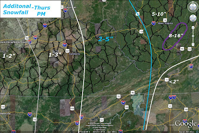
So here's my thoughts for Totals through Thurs evening:

So most of SE KY gets an additional 1-3"s with the mountains of eastern KY getting 2-5". Tomorrow will be very windy, cold and blustery with blowing snow so be careful while traveling and make sure to stay warm. Wind Chills could go below zero tomorrow night so be on the look out for that. We'll have more on how things are playing out and a look at the extended range forecast tomorrow, so until then take care!


1 comment:
thanks for painting me in the 1"-3" range in Pulaski Co. Shane!! However I don't think it'll pan out that way. I'd go more with 1" or less and lean heavy on the less side!!!..lol Thanks for the update!
Post a Comment