Saturday, March 28, 2009

Severe Weather Possible Today

Hey folks, We do have a chance at severe weather later in the day so I thought I would post my opinion on the situation.

So when looking at severe weather potential, there's a little cookbook of ingredients I like to look at. Without getting into too much meteorological rhetoric, you need 4 ingredients:

1. Instability
2. Wind Shear
3. Lift
4. Moisture

Okay lets go through today's set up and see what we have.

Instability is the biggest thing working against severe weather today. Usually to generate instability you need nice Sunny Skies and tons of energy being cranked in from the sun. Lets look at the latest visible satellite.


As you can see the cloud deck is nice and thick this morning except over a few parts of south central KY, and western TN. This should limit instability, and the latest RUC model agrees with it's measurement of CAPE.


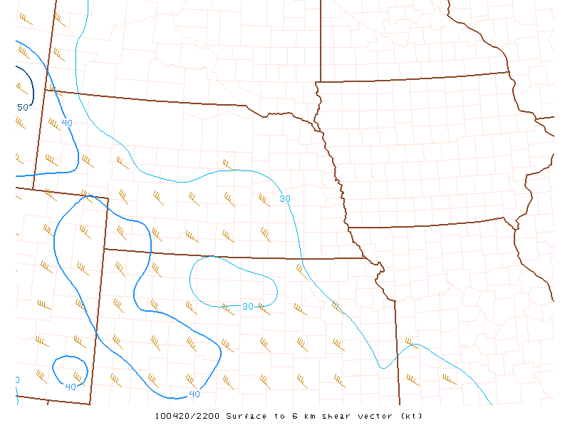
Wind shear is something we have a decent amount of today.


Lift today is going to be caused by the cold frontal passage, so there is no question we will have lift caused by the front. Moisture is looking decent today with dewpoints in the 50's and forecasted to get near 60.

So my thoughts are that south eastern KY's biggest threat will come in the form of a squall line passing through the state tonight. High winds will be our biggest concern tonight. I will be at work when this thing passes so here's a map with the latest watches and warnings... I think it should auto update.

So keep an eye on the sky and an ear to a NOAA weather radio or local media outlet to get the latest info.

Tuesday, March 24, 2009

Active Couple of Days

Time to get back in the habit of daily blogging.

Your 5-day Forecast for London KY:

Wednesday: Showers and Thunderstorms are likely, espeicaly early morning. Winds will be gusty. Low of 52, High of 61.

Thursday: Showers once again likely, maybe a rumble of thunder or two. Low of 53, High of 58.

Friday: I think we catch a break in the action for a while with partly to mostly cloudy skies, and scattered showers possible later in the day. Low of 46, High of 62.

Saturday: Showers and Thunderstorms likely, some could be strong to severe. Winds will be very gusty as well. Low of 52, High of 65.

Sunday: Showers, Gusty Winds, and Mostly Cloudy skies are in the forecast with temperatures falling throughout the day. An after midnight of near 60, with temperatures falling in the mid to low 40's by the afternoon. For the sake of the forecast we'll go High of 62, Low of 43.

Monday, March 16, 2009

Monday Morning Update

Your 5-day Forecast for London KY,


Monday: Partly Cloudy with a few isolated showers not out of the question. Low of 49, High of 57.

Tuesday: St. Patty's day is looking awesome! Mostly Sunny, Low of 40, High of 64

Wednesday: Mostly Sunny skies stick around with clouds increasing towards the end of the day. Low of 47, High of 70.

Thursday: A cold front moves through the state bringing us showers and thunderstorms. Windy with cooler temperatures falling through the day. After Midnight High of 52 Low of 43.


Friday: Sunny but pretty cool to start the day. Low of 28, High of 46.


Forecast Review:

Sunday: Mostly cloudy with scattered showers tapering off by the end of the day. Low of 43, High of 56. Actual: 44/58

So not a bad forecast at all! Forecast is looking on track right now for the next couple of days, enjoy St. Patties day! Wednesday will be ever better. I'm thinking March might go out like a lion.


Saturday, March 14, 2009

Sunday Morning Update

Good Sunday Morning one and all! I hope you are having a great Sunday. I apologize for the lack of updates recently. I've been busy at work and in my social life right now and have had to put weather back home on the back burner for a few days now. But excuses aside, it's time for an updated 5 day forecast and a couple of days we're I'll have some free time to blog.

Your 5-day Forecast for London KY,

Sunday: Mostly cloudy with scattered showers tapering off by the end of the day. Low of 43, High of 56.

Monday: Partly Cloudy with a few isolated showers not out of the question. Low of 48, High of 58.

Tuesday: St. Patty's day is looking awesome! Mostly Sunny, Low of 40, High of 63

Wednesday: Mostly Sunny skies stick around with clouds increasing towards the end of the day. Low of 47, High of 67.

Thursday: A cold front moves through the state bringing us showers and thunderstorms. Windy with cooler temperatures falling through the day. After Midnight High of 54, Low of 42.

Well talk again tomorrow night! Until then try to stay dry and have a good one!

Tuesday, March 10, 2009

Tuesday Night Update

A Quick 5-day Forecast for London, KY:

Wednesday: Thunderstorms possible early morning, winds will be gusty and temps will be falling throughout the day. Clouds will clear up after our storms move through. After midnight High of 68. Low of 39.

Thursday: Thursday should be Mostly Sunny, with clouds increasing late and just a slight chance of a rain or snow as a warm front moves northward. High of 40, Low of 31.

Friday: Canadian High pressure moves in for Friday, leaving our skies partly cloudy as the frontal boundary remains just to our south. A few scattered showers can't be ruled out. A northern wind rushing in cooler air for the morning, but some warmer air for our afternoon. Low of 27, High of 47.

Saturday: Our frontal boundary checks back to the north and brings us a better chance of showers. Low of 35, High of 46.

Sunday: An even better chance of showers as low pressure moves through the area. High of 60, Low of 38.

I'll have more details tomorrow night. Sorry for the lack of posts the last few days, between work, my parents visiting, and just some unwinding time I needed yesterday and today, I haven't been too focused on the weather.

Sunday, March 8, 2009

Severe Weather Possible Today

Hey folks, quick update before I go into work today. We are under a risk for severe weather today.

I would not be surprised if we are put under a tornado watch later in the afternoon. I expect the squall line to move through London sometime between 9 PM and Midnight. Main threats are damaging winds, isolated large hail, and isolated tornadoes. I will have a full update including a new 5-day forecast later tonight. Until then stay safe and keep an eye on the weather, especially this evening.

Thursday, March 5, 2009

Wow What a Warm Up!

Hope you enjoyed the alliteration in the title as much as I'm enjoying the warmer weather! I hope you are also enjoying the warmer weather, and you 5-day forecast is also looking quite warm.

Your 5-day Forecast for London, KY:

Friday: Partly Sunny with an isolated chance of showers. Low of 49, High of 70!

Saturday: Mostly Sunny and warm! Low of 48, High of 74!

Sunday: Clouds increasing through the day with a chance of showers and thunderstorms later in the day. Low of 55, High of 67.

Monday: Showers continue mainly in the morning, otherwise Partly Cloudy. Low of 44, High of 57.

Tuesday: Mostly Cloudy with a chance of showers later in the day. Low of 52, High of 67.


So after a much need couple of days backing off the weather, just keeping a passing eye on it, I'm feeling much refreshed. I'm still concerned about a cool down again towards the middle of next week, but we'll burn that bridge when we get there! In the mean time enjoy the warm temperatures and have those umbrellas handy on Sunday. We'll talk again soon.

Monday, March 2, 2009

March Comes in Like a piece of Frozen Lamb

Your 5-day Forecast for London, KY:


Tuesday: Mostly Sunny and cold. Low of 11, High of 27.

Wednesday: Mostly Sunny. Low of 23, High of 47.

Thursday: Partly Cloudy with a slight chance of a scattered shower. Low of 37, High of 60.

Friday: Partly Cloudy with another slight chance of showers. Low of of 49, High of 56.

Saturday: A Chance of Showers or Thunderstorms, otherwise Mostly Cloudy. Low of 52, High
of 64.


Forecast Review since last 5-day:

Saturday: Chance of Rain Changing to Snow late. High of of 42, Low of 30 Actual: 41/31

Sunday: Chance of Snow, otherwise Mostly Cloudy. High 34, Low of 22. Actual: 38/24

Monday: Chane of Scattered Snow Showers, otherwise Mostly Cloudy. High of 26, Low of 17. Actual: **/16 *Will update later*

Well I'm pretty happy with my temperature forecasts, hey if I'm going to miss the snow totals at least I got temps pretty close!

Forecast Discussion:

Okay things are looking cold in the short term as serious Arctic high pressure moves in to clear us out. It would not surprise me if some of the sheltered valleys hit single digits for lows tomorrow morning.


Once that high moves east of us and our winds shift to the south we should start the warm air conveyor belt from the Gulf of Mexico. Temps might make a run at 70 by the weekend as we get a pair of storm systems rolling in from the planes. First things first, lets look at our Friday set up.

Storm 1:

GFS:


DGEX:


Canadian:


Euro:

Pretty decent agreement for our Friday system as a week cold front moves through. Temperatures won't drop much with it and we should just see an increase in clouds and some showers and maybe some rumbles of thunder. Now for the weekend, where things aren't looking as clear.

GFS:


DGEX:


Canadian:


Euro:


Okay let's break this down. GFS and DGEX *Which takes the NAM's data to start up and the carries out where the NAM cuts off with GFS data.* is showing a big storm getting wound up in the planes and the precipiation it is showing for us is due to a lifting warm front hooked into that storm.

The Canadian says, not so fast... I'm going to develop a storm on the east side of the Appalachians and try to wrap in some colder air for Sunday.

Then the Euro says, hang on, hang on! I'm going to bomb out our Friday system and just open the door for some cold air to come in for the weekend.

So which one's right... I'm honestly hoping the GFS. I'm tired of the cold and snow. We ended up picking up an inch last night here in WV when no model was showing it. I'm just ready to get some warmer and Sunny weather in for a couple of days to give this weather dude a break. I'm filling in again tonight at the station, so only a one day weekend tomorrow which I am looking forward to! I still think we have the chance at one big winter storm before we wrap up the season. The GFS is trying to spit out a monster storm for the 13th... but that's 11 days from now and I'll deal with it here in about 6. Until we talk again, have a great day and take care!

Sunday, March 1, 2009

Snow No Go?

Just a quick update before I head out for the evening. It looks like a pretty serious dry slot has worked in and it's going to cut our snow totals down. Not to mention we had a nice period of sleet as well to our north. So If we can get 1-3 inches of snow at this point I'll be happy... but I'm really not sure we'll see that much. Just keep an eye on Radar, and specifically the track of the upper level low.


I'll have an updated 5-day sometime tomorrow *Maybe after Midnight*. Until then take care! And be careful because there could be a few slick spots out there tonight.