Sunday, May 17, 2009
Sunday 5-day
Monday: Partly Sunny. Chilly Morning low of 39, High of 68. We could see some Valley frost Monday morning.
Tuesday: What a beautiful day! Sunny skies with a low of 37 (Once again keep an eye out for some frost in the valleys) and a high of 79.
Wednesday: Sunny, Low of 55, High of 83.
Thursday: Sunny, Low of 62, High of 85.
BTW, this is my 100th post woohoo! Thanks to everyone who stops by to see my humble opinion of the weather.
Saturday, May 16, 2009
Afternoon Update
The line of thunderstorms ahead the cold front is refiring right now. Some of these could cross the severe threshold. Here is a radar to track where the storms are:

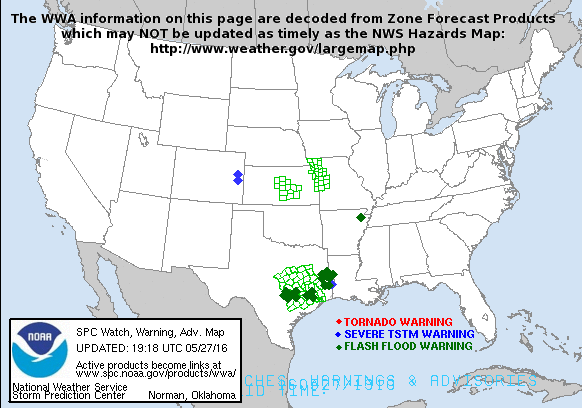
And here's the latest watches and warnings:

I'll have an updated 5 day forecast tonight.
Friday, May 15, 2009
Welcome to the Weekend!
It's going to be a humid weekend, with showers likely Saturday Night into Sunday Morning.
Here's your 5 day forecast for London, KY:
Friday: Scattered showers and thunderstorms possible, otherwise Sunny! Low of 64, High of 82.
Saturday: Partly cloudy, with a chance of scattered thunderstorms, best chance in the afternoon and evening. Low of 65, High of 79.
Sunday: A good chance of showers and thunderstorms early, with skies clearing towards the end of the day. High of 66, Low of 42.
Monday: Partly Sunny. Chilly Morning low of 39, High of 68. We could see some Valley frost Monday morning.
Tuesday: What a beautiful day! Sunny skies with a low of 37 (Once again keep an eye out for some frost in the valleys) and a high of 79.
Forecast Discussion:
So I think today is actually going to end up being mostly dry until later in the day when a few showers could spark off. Here's a radar to keep track of any showers or storms that do pop up.

Our best chance of rain will be on Saturday Night/ Sunday Morning:
NAM Saturday Evening:

NAM Sunday Morning:

And finally some good news. Both the GFS and NAM are backing off rainfall totals for the weekend, which is good news for the folks recovering from flooding in Eastern KY.
GFS:

NAM:

The NAM is showing around a half inch for most of Eastern KY, while the GFS is showing around an inch. That's not great, but much less than the 3-4"s some models were showing earlier in the week. After we deal with the rain for the weekend things are looking great for next week with Sunny skies and high temperatures near 80 for most of next week. Next weekend might be another story however. Also keep an eye on the tropics the next couple of weeks. Some the GFS and GEM individual ensemble members are trying to spin up some tropical activity in the next two weeks. So keep an eye on that and the rain for the weekend. We will talk again soon, until then take care!
Wednesday, May 13, 2009
Here Comes the Rain
Wednesday: Isolated Showers possible, otherwise Mostly Cloudy. Low of 49, High of 76.
Actual: Low 53, High of 75.
Overall not a bad forecast, now your Five Day Forecast for London, KY:
Thursday: Showers and Thunderstorms are likely in the afternoon. Otherwise Mostly Cloudy. Low of 62. High of 75.
Friday: Scattered showers and thunderstorms possible, otherwise mostly cloudy. Low of 64, High of 74.
Saturday: Partly cloudy, with a chance of scattered thunderstorms. Low of 65, High of 80.
Sunday: A good chance of showers and thunderstorms. Temperatures look to be falling through the day with a morning high of 71, and a low that evening 48.
Monday: Partly Sunny. Chilly Morning low of 38, High of 67.
Forecast Discussion:
So things still seem on track from this mornings post. The NAM is really cutting back our chances of rain tomorrow as the front moves through:
Tomorrow Morning:

Tomorrow Afternoon:

I think it might be weakening those showers out a bit to much as the front moves into the area, but we will see. Things also look wet through the weekend, but finally High Pressure builds in at the beginning of next week.
GFS Monday Afternoon:
 Notice that mass of precip down in FL, that might be the first tropical system of the season trying to develop. I think that we should stay dry for the majority next week. High Pressure seems like it will build in for at least a couple of days, and it'll be a welcome sight to help flood recovery efforts.
Q&A:
Anonymous said...
Shane,
When will this pattern end? Do you see any indications in long range models that we might actually have more typical late spring weather? This rain and fronts stalling out is brutal. I'd love to see a strong High move our way and setup camp for a couple weeks. Thanks for the updates.
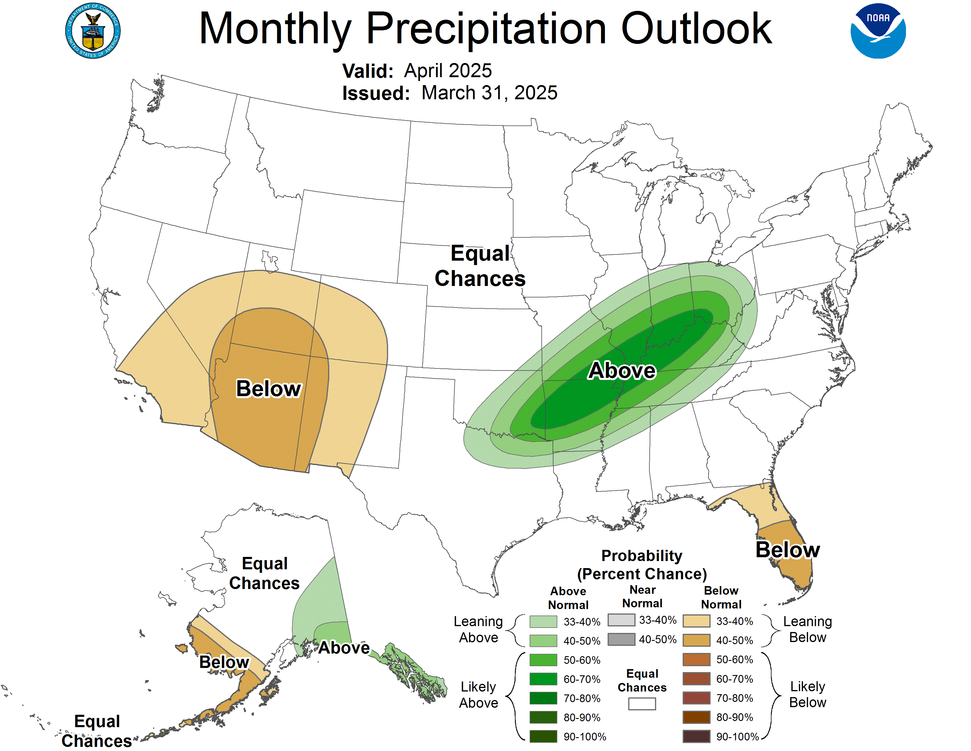
Well Anonymous, while I do see high pressure building in for the first part of next week, I'm not sold on the fact that'll we see see a big southeastern ridge build in the next few weeks. Most the things I look at for long range forecasting *Which is still my weakest area of forecasting, but I'm still trying to learn* point towards a continued active period in the weather. Next week like I said earlier shall be dry, but I don't think that ridge will hold. The CPC shows the next month to continue to be wetter than normal:
That's all for now, we'll talk again soon.
Rainy Days Ahead
Wednesday: Isolated Showers possible, otherwise Mostly Cloudy. Low of 49, High of 76.
Thursday: A much better chance of showers, and thunderstorms later in the day. Some of which could be on the strong side. Low of 58. High of 73.
Friday: Scattered showers and thunderstorms possible early, otherwise mostly cloudy. Low of 56, High of 75
Saturday: Partly cloudy, with a chance of scattered thunderstorms. Low of 64, High of 80.
Sunday: A good chance of showers and thunderstorms. Temperatures look to be falling through the day with a morning high of 71, and a low that evening 48.
Forecast Discussion:
Well once again a very rainy few days is in store for us. Here is a look at radar to track the rains through the day.
 The good news for today is it looks most of the rain with the warm front that's moving through will stay north of us. The bad news is that as the cold front behind starts to move through, It's going to slam the breaks and move in like that uncle that always over stays his welcome. Here's a look at the models to see when we get this boundary out of here.
Thursday Afternoon:

Friday Afternoon:

The front stalls out until another Low Pressure system slides in behind it and finally pushes the entire mess on out of the area. This will start on Saturday.
Saturday Afternoon:

Sunday Morning:

So the GFS is backing off it's total rain for the period through Monday, but we still could see a couple of inches in eastern KY, which is not what we need.
Rain through Monday:

So I'll be keeping an eye on the water levels through the weekend. Until we talk again take care!
Monday, May 11, 2009
The Week Ahead and a Look at WV Flooding
Tuesday: Mostly Sunny, Low of 44, High of 74.
Wednesday: Isolated Showers possible, otherwise Partly Sunny. Low of 49, High of 72.
Thursday: A much better chance of showers, and thunderstorms... some of which could be on the strong side. Low of 58. High of 73.
Friday: Scattered Showers and thunderstorms possible, otherwise mostly cloudy. Low of 56, High of 77
Saturday: Partly cloudy, with a chance of thunderstorms later in the day. Low of 62, High of 78.
Forecast Discussion:
The week ahead is not good for those out in eastern KY trying to pick up the pieces after Friday's severe weather and flooding. The storm system that moved through was nothing short of amazing. The day I think we're really going to have to watch out for is going to be Thursday as a cold front moves through.
GFS Thursday:

Then We see more scattered showers off and on as we go into the weekend, culminating in another frontal system moving through Sunday:
GFS Sunday:

Total rainfall for the next week is a little scary looking considering the amount of rain we've seen recently.
Total Precipation through Next Monday:

So I will be keeping an eye on the flood threat through next week. To finish tonight pictures of flood damage from Wyoming Co. WV I took while doing a story there for the News last night.


Saturday, May 9, 2009
Flooding Rains Continue
5-day Forecast for London, KY
Saturday: Showers are going to stick around for most of the day, but I think we'll get them out of here by the end of the day. High of 71.
Sunday: I think we're going to keep the majority of showers off to our south for Mothers day. We're going Mostly Cloudy to Partly Cloudy. with a High of 67. Low of 51.
Monday: Scattered Showers return to the forecast. High of 65. Low of 47.
Tuesday: MOSTLY SUNNY! I haven't had that in a forecast in a long time :P. High of 74, Low of 49.
Wednesday: Partly Sunny with clouds increasing throughout the day leading to scattered showers and thunderstorms by the night. High of 76, Low of 51.
Yesterdays weather:
All I have to say is I've never seen a storm system like that yesterday. It was truly a thing of beauty on radar, but left destruction in it's wake. Several reports of damage across the state, as well as a fatality in Madison county from a possible tornado. Here's a look at all the storm damage reports from yesterday.
National:

Local:

As you can several reports of wind damage and hail in the state. Not only did we have the severe weather but we also saw a tremendous amount of rain. Here is the Doppler Estimated Rainfall so far, and the latest flood watch and warnings.
Radar Estimated Rainfall:

Watches/Warnings
 Okay I know this map might be a little hard to read. The counties in the duller green are under a flash flood watch, the counties in the brighter green are under a flash flood warning. And the counties with gray boxes over them are under a flood warning. As you can see in that radar image some areas Doppler radar estimated over 5 inches of rain with the storms so far yesterday/this morning. The ground was already saturated yesterday in many areas, so most of this water is going to pond or run off into the streams and rivers. If you live in a flood prone area in eastern KY keep an eye on the water level. I'm hoping we stay dry enough this week that we don't have any more flooding issues, but I'm seeing chances of rain on Monday, and Wednesday night/Thursday.
Monday Afternoon NAM Model:

Thursday Morning GFS Model:
 We could see more severe weather with this cold front as it moves through Thursday, but I don't suspect it will be as strong as the round of severe weather we saw yesterday. Well that's all I have for now. Take Care and stay safe until we talk again.
Tuesday, May 5, 2009
Flood Threat Continues
Tuesday: Scattered showers and thunderstorms, otherwise mostly cloudy. High of 75.
Wednesday: Scattered showers and thunderstorms, otherwise mostly cloudy. High of 68, Low of 62.
Thursday: More of the same, scattered showers and thunderstorms, otherwise mostly cloudy. High of 77, Low of 55.
Friday: Once again more scattered showers and thunderstorms, otherwise mostly cloudy. High of 72, Low of 58.
Saturday: More scattered showers and thunderstorms, otherwise mostly cloudy. High of 63, Low of 56.
Forecast Discussion:
So the wet pattern continues. So what exactly is causing this extended period of unsettled weather? I'll try to answer that for ya. Basically the jet stream is a parked right on top of us.

And as it kind of waves back and forth on top of us for the next week, we'll see small low pressures systems over top of us, each one bring us a chance of showers and thunderstorms. And the possibility is there to see more heavy rain. Here's the 7-day rain out look from HPC:
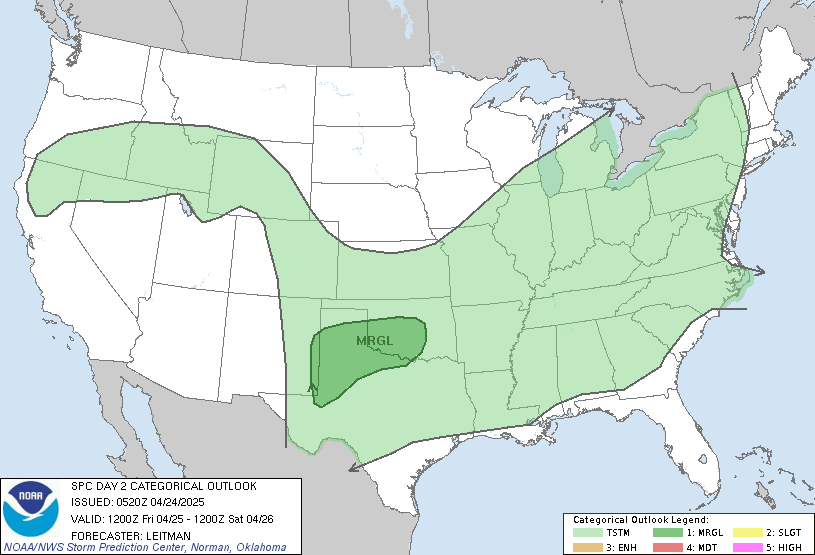
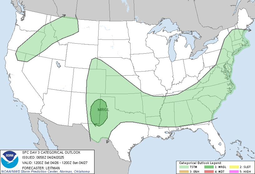
 4 inches of rain over the next week is the last thing southern KY needs right now. There were already several reports of flooding over the weekend, and if we keep adding on more and more rain I suspect it will only get worse. We also have a slight chance at severe weather for Wednesday and Thursday.
Wed:

Thurs:

I'll keep an eye on it and will have more info as it becomes available. I'm working morning shift again tomorrow so I'm not sure when I'll update again just yet. We'll talk again soon.
Monday, May 4, 2009
Flooding LIkely Tonight
BULLETIN - EAS ACTIVATION REQUESTEDSo just how much rain have we seen? Here's a look at Doppler Estimates:
FLASH FLOOD WARNING
NATIONAL WEATHER SERVICE JACKSON KY
1148 PM EDT SUN MAY 3 2009
THE NATIONAL WEATHER SERVICE IN JACKSON KY HAS ISSUED A
* FLASH FLOOD WARNING FOR...
EAST CENTRAL LAUREL COUNTY IN SOUTH CENTRAL KENTUCKY...
EASTERN WHITLEY COUNTY IN SOUTH CENTRAL KENTUCKY...
BELL COUNTY IN SOUTHEAST KENTUCKY...
CLAY COUNTY IN SOUTHEAST KENTUCKY...
WESTERN HARLAN COUNTY IN SOUTHEAST KENTUCKY...
KNOX COUNTY IN SOUTHEAST KENTUCKY...
SOUTHERN LESLIE COUNTY IN SOUTHEAST KENTUCKY...
* UNTIL 545 AM EDT
* AT 1144 PM EDT...NATIONAL WEATHER SERVICE DOPPLER RADAR INDICATED
A BAND OF VERY HEAVY RAINFALL MOVING INTO THE WARNED AREA PRODUCING
RAINFALL RATES OF UP TO THREE-QUARTERS OF AN INCH PER HOUR.
* LOCATIONS IN THE WARNING INCLUDE BUT ARE NOT LIMITED TO AREAS IN
THE VICINITY OF BARBOURVILLE...HARLAN...HYDEN...LOYALL...
MANCHESTER...PINEVILLE...MIDDLESBORO...SOUTH WALLINS AND WALLINS
CREEK.
FLASH FLOODING WILL LIKELY BE CAUSED AS VERY HEAVY RAIN FALLS ACROSS
THE AREA IN COMBINATION WITH RUNOFF FROM RECENT RAINS. BE ESPECIALLY
CAUTIOUS AT NIGHT WHEN IT IS HARDER TO RECOGNIZE THE DANGERS OF
FLOODING. IF FLASH FLOODING IS OBSERVED ACT QUICKLY. MOVE UP TO
HIGHER GROUND TO ESCAPE FLOOD WATERS. DO NOT STAY IN AREAS SUBJECT
TO FLOODING WHEN WATER BEGINS RISING. ALSO...WHEN ENCOUNTERING
FLOODED ROADS MAKE THE SMART CHOICE...TURN AROUND... DONT DROWN

Those Darker reds indicate over 5 inches of rain in parts of McCreary County. Streams and rivers are likely to rise over night and through the day tomorrow so if you live in a flood prone area keep a sharp eye on the water level. That's all I've got for tonight, we'll talk more tomorrow.


